


“Universul lui Salvador Dali” @ ARCUB, Bucharest


“Victor Brauner Intre Oniric si Ocult” la Muzeul de Arta al Romaniei, Bucuresti


From Budapest the plan was to fly to Bucharest but in order to keep up with the flow of history I changed plans and took a train to Bratislava. As a kid in school I remember learning about the Hungarians’ defeat in front of the Ottoman’s armies at Mohacs in 1526. But there were way more pressing things to explore at that age than to study the aftermath of that battle. Nor, many years later when I backpacked through Czechoslovakia in 1980s I found any emphasis in Bratislava of its glorious aristocratic past, unwelcome otherwise in the workers’ paradise.

The Ottoman victory in 1526 signed the end of Hungarian kingdom. Its western territorial remains forced the court to move to Bratislava, named by the Hungarians, Pozsony and by the Austrians, Pressburg. The city’s new latin name was coined in 1919 but its roots go back to the first millennium when it was mentioned as Vratislaburgum, Braslavespurch or Preslavasburc by Slovaks, Czechs or Germans.

The remaining Hungarian territory, a third of the original Hungarian kingdom was incorporated in the Habsburg empire and Bratislava/Pzsony/Pressburg served as the Hungarian capital from 1526 until 1784. The Hungarian parliament continued to meet there until 1848.

During this time 19 Habsburg rulers were crowned kings of Hungary in the city’s Gothic Cathedral of St. Martin, the city becoming a coronation place not only for kings, but also for archbishops and nobility. Maria Theresa, the famous queen of the Habsburg Empire was crowned here in 1741.

The city, named Pressburg in those time flourished during the reign of Maria Theresa, and became the most important city in the Hungarian Kingdom. It became also the largest, its population tripling.

But enough with history. Bratislava ended up as the last stop on my European foray before I reach Bucharest. A totally unplanned trip that started with a whimsical desire to stop in Budapest before I arrive in Bucharest, and for which I planned for logistical reasons to fly into Vienna. But the plan evolved organically and ended up porting me in 6 countries and 5 capitals, crossing Europe west to east by train, avoiding as much as I could flying. I hoped the train would slow down my OCD of intense travel and it sort of did, maybe not enough but always it’s a beginning for everything.

But my travel-by-train plans stopped at the Romania’s borders where train travel is painfully slow, even slower now than during the communist period. So I searched flights to Bucharest from one of these Eastern European’s capitals just to find that the connections between these ex-brotherly countries are atrocious. There is only one direct flight from Budapest to Bucharest and none from Bratislava. Besides the price of these flights exceed a high-tier intercontinental flight. There are even less expensive flights from New York to Budapest than to fly TAROM from Budapest to Bucharest (!)

But Bratislava is just one hour away from Vienna, either by train or by boat cruising over the Danube. I hopped in one of the trains that brought me back to Vienna and flew from there to Bucharest for an insignificant cost. And now I can relax a bit after the long walks I put in these countries that averaged 14 miles/day.


While walking in Pest you could see from many locations the palace perched on the hill across the Danube. Buda Castle was the seat of the kings of Hungary ruling from Buda established as capital in 1361. Buda and Pest were separate cities. They united and formed Budapest in 1873 making it the second-largest city of the Austro-Hungarian Empire after Vienna. Pest got conquered by the Ottomans in 1526, and 15 years later Buda fell also under their rule becoming capital of the Budin province during the Ottoman rule and they stayed like this for almost 150 years when the Habsburg took over defeating the Turks.

In the middle of the square topping Buda hill, Mathias Church, founded in 1015 was used for centuries as a coronation site by Hungarian kings. It was rebuilt in gothic style in the 14th century and restored in the late 19th century. Near the church is the statue of St Stephen statue the founder of Hungarian kingdom, credited also for christianizing the Hungarian tribes. As a result he got promoted from king to saint.

But the main structure that can be seen on Buda hill is the Fishermen’s Bastion, a romantic reinforcement built at the beginning of the 20th century. There was no defensive intent in its construction but for beautification of the town on the place where it seemed that the fishermen guild brought their products to the market around Mathias Church. But the story goes that for this benefit the fishermen had to defend the thick walls of the citadel at this specific location.

A short walk from the Fishermen’s bastion is the Buda Castle that host the Hungarian National Art Museum and just nearby is the newly renovated palace of the Hungarian president.From the hill you can descend by a funicular with amazing views over Széchenyi Chain Bridge, the famous chained bridge of Budapest.


It was a long walk around the Buda Hill’s sites and I was rushing at one point because I had to catch a train to Bratislava. I walked the Chain bridge in Pest and in the last hour I had available I went to visit the House of Terror, the museum dedicated to what the Hungarians call, the two occupations, the Nazi and Communists, identical brothers in ideology. The museum was developed in the building once occupied by the Nazi party just to be taken over after the war by the Hungarian Secret Police. Conveniently, they just changed labels and applied the same terror to the people.

On the museum’s first floor is a tank used by the Soviets in quashing the 1956 revolt of the Hungarians zesting for freedom. The museum exhibits are spread on two floors before descending into the basement where the torture chambers and the jail were preserved intact together with the torture devices. But what strikes most is the chagrin the museum’s films and regular folks’ interviews exude, all explaining how the communists will destroy the country. It’s a sentiment of powerlessness combined with anger and rage for the crimes those people committed and total disgust for the communists that brought the enslavement and emasculation of an entire country.

Somehow I always ignored visiting places close to home. Irrelevant what that home might be. I traveled from Ushuaia to Fairbanks and from the tip of Sri Lanka to northern Japan but I never went to Ruse, and implicitly to Bulgaria, 60 km from my original home town, Bucharest. The same happened with Kishinev, Belgrade or Budapest. At the beginning of the 1980s I spent probably around 8 hours in Budapest, a short stop between two trains while backpacking in Eastern Europe, the only countries we were allowed to visit in our extended jail, “the paradise of workers and peasants”

I remembered vaguely Budapest of those times with imposing buildings and decrepit facades, a gray city of communist poverty but way more opened to the western culture that our Romanian dictatorship would allow. And in those time this opening manifested through music and consumer goods completely lacking in Romania was obsessively more important for us that any other cultural aspects. So I wanted for many years to revisit Budapest and I kept postponing probably because …it was too close.

Coming from Vienna my old-life misconceptions shaped in my mind a toned down Budapest just to be startled by its new look. I found a monumental city with large boulevards lined up by lavish villas hidden behind leafy trees, houses owned once by the Hungarian bourgeoise, taken over later by the Communist apparatchik and now by the nouveau riche. A city that strives to prove that is still an important capital of a once powerful but now vanished empire, the capital of Hungary that history made it smaller and smaller, always choosing the wrong side of history as they chose today a path against the entire Europe.

However Budapest is amazing through its conservation effort, a city where old architecture is preserved with intense energy on an accelerated rhythm giving the feeling that everywhere people are working non-stop on renovating their city most probably with European funds. The newly opened museums like the Ethnographic Museum and the House of Music from the City Park are splendid newly built architectural jewels.

So a stroll in Pest, on the Eastern bank of the Danube, is a walk of discovery strolling the roof on the new ethnographic museum, to the cathedral and the gorgeously renovated palace that houses now the public library filled with students studyIng.

The sun setting behind Buda Hill drowns all Pest buildings by the river in a magical orange hue inviting for a stroll and admire the glory of the divine light.

In the godly hue of the sunset the shoes memorial of the Jews murdered towards the end of the war is even more powerful. They were executed along the river bank by the members of the Hungarian Arrow Cross party police around December 1944 and January 1945. More than 20,000 jews taken from the ghetto perished in that short period.

I found Budapest swamped by tourists buses, everywhere you went you could see groups after groups herded by guides telling stories in all languages. I was wondering how crowded may be the city in summer if it were packed like this in the whimsical April.

And nowhere you see more people that on the night Danube cruises – a must do in Budapest – that were fully packed.

And after such a long walk in Pest the best place to chill is in one of the Ruined Pub, great hang out places about which I heard lots of praises. These places are bars built in former abandoned buildings that became the cool places to go in Budapest, most of them developed in the Jewish Quarter. I read that the one such bar opened in 1999 but the one considered the first pioneer ruined bar in Budapest is Szimpla Kert opened in 2002.

The bar takes over an entire building that is large and mainly deep, on two or more floors embracing the building’s natural decay, decorated with old furnishing and bizarre decor, many times a pastiche of weird elements that are visually striking.

The chill images should be augmented with the music that pumps in each and every room, with people dancing and changing rooms depending on their mood. The electric atmosphere of the place kept me there till midnight in spite of the almost 20 miles that I walked that day.


The rain that deluged Vienna the day before I welcomed because I was able to time it with some museum visits. But you need a lot of rainy days to cover Vienna’s treasure trove of museums, one seemingly better than the other.

So when I woke up in the morning and saw clear skies I left for an extensive walk in a city that I did not see till 1990. And the marathon was for sure the unexpected surprise because when you travel you worry about many other things than the next marathon.

The beauty of it is that you can watch the marathon from various point of the city and admire its monumental architecture in the same time. And it’s no effort to detour your walk because the organizers marked the running path to follow the beauty of this fabulous city.

The arrival was in front of the city hall after the runners followed the ring and were welcomed by pumping music, lots of crowds and of course a lot of police who were watching the crowds.

Locals and lots of tourists were packing the avenues, many caring posters encouraging the runners while others had cow bells banging them continuously. But overall it was nice, sunny Sunday morning and people went out with families and lots of babies and toddlers having just a relaxed time in a very quiet, relaxed and safe city.

My last day in Vienna in my European periple. I wanted for a long time to travel in Eastern Europe by train. In the USA we always fly from one point to another and train seems to be there a thing of the past. Of course there is no incentive to improve trains like in all things in the States where business trumps the interest of the people. And more than anything I wanted to travel in Eastern Europe since I have been in Croatia many years ago. It’s more lively, less stressed, people feeling that even if they may earn less, live a more relaxed and connected life. Of course when you come from New York it seems that everybody in the world seems relaxed 🙂 When I descended in Budapest’s Keleti lots of young, nice guys and girls stayed behind. Were they going to Ukraine or maybe they would stop somewhere along the way to the border? Or maybe they were going to enroll to defend their country of the invasion created by the maniac (Ras)Putin? Or they were just visiting the country they love but they cannot live in it because of the terrorist disaster created by the Russians? I could not know their intentions and all I followed was those stupid debates in the American congress to give them arms to defend their country and with it our way of life. And this war is also a marathon, a marathon of life and death but at whose end you don’t win a medal but a country and a way of living.

Most of the people know Friedensreich Hundertwasser as a remarkable painter. An artist whose graphic designs seem to dive into a more profound spirituality of the visible and inspire the viewer that admires his work. His colorful spirals dominate his many collections, twisting and turning, like delving in an absconded realm that he could effortless see even if we try pointless to figure it out its meaning.

His architectural designs try to avoid straight lines – “the straight line is God less”, he said – embedding in the rooms unregulated irregularities. He strives for a humanity in harmony with nature, with trees growing in windows and flowers coming out of the floors. These trees are called tree tenants and he had an entire manifesto regarding their use and right to be there, cohabitating with humans in windows and balconies.

Besides, Hundertwasser was a philosopher and mainly an activist for ecology in a time when this was not a cool thing to do. He wrote letters and manifestos, speeches and public performances criticizing the doctrine of permanent growth that is so alive mainly today, the wasteful society and the ridiculous conformism of the society. Probably he would die again to see the fake corporate culture spread across the world.

Not far from Hundertwasserhaus Museum is the place where another modern, this time the Romanian poet Mihai Eminescu lived while studying in Vienna where not having yet the baccalaureate exam he was accepted as an extraordinary auditor. The word went that Eminescu seemed to lack money. I don’t know how the neighborhood looked in his time but for sure now it is a very spiffy location.

Modernism in Vienna’s turn of the 20th century arrived on top of ruins and devastation caused by the war. The empire collapsed forced by huge inequality and poverty of the masses and acute tensions among many of its nationalities.

The exhibit at Leopold Museum presents this remarkable advent of the new modernist current in all its aspects, a wealth of artistic and intellectual achievement. At the time of this explosive movement towards modernity Vienna was the city of contradictions that lived side by side: nobility and liberals intellectuals, magnificent building and the squalor of the slums, Zionism and anti-semitism.

The remarkable Secessionists and the concept of the Gesamtkunstwerk, or universal work of art brought art to all areas of life. The Austrian Expressionism started exploring the soul extracting feeling that showed a dissolution of the self, a subject kept tabu for generations by exactly that conformity of the society that I mentioned above. A lot of these artists were part of the new bourgeoisie, many of them Jewish who later on had to flee Vienna, leaving behind them a vacuum of creativity.

From painting, to furniture to architecture to sculpture to jewelry and poster design the exhibition passes through all forms of art that made Vienna what was renown for in its heydays. But what is impressive of this exhibition “Vienna 1900 Birth of Modernism” is the breadth of art of all kinds, from paintings to decorative and home use objects brought from private collection to fill three floor of this remarkable museum.


I passed by at the Kinsky auction house in Vienna where it was the pre-auction viewing of a number of Klimt drawings and a portrait of Margarethe Constance Lieser, the daughter of Adolf Lieser. Actually the auctioneers were not sure if the painting depicted her or one of the two daughters of Justus Lieser and his wife Henriette but no matter who the woman was the guy who won the auction paid 30m for it days latter. Anyway I planned to be in Budapest for the day of the auction so I decided to pass on bidding against whatever Arab sheik or a rude Russian disguised as a gentleman. Better a goulash by the Danube…

Somehow I was obsessed with Melk. First time I’ve been to Austria way too many years ago I stopped at the monastery mentioned in Umberto Eco’s “Il Nome della Rosa”. In writing his novel Eco found its inspiration in Melk’s library that he depicts vividly with intricate details. His mention of Egypt, a large slice of the library adds the desired element of mystery hidden in the encompassing collection of volumes. One interesting note in the library is the globe that shows America as a continent but with with a separate California as an island. Geological or political prophecy? Walking through the library, you can imagine spotting among the tourists the young disciple Adso di Melk, navigating the intricate labyrinthine of corridors looking for hidden treasures within the shelves.

The story goes that St Benedict left Rome disgusted by the opulent and deprived life that was the norm of the empire’s capital and went to live in isolation where he crafted his theological doctrine. His doctrine was adopted in Melk and for centuries was loosened and tightened with the coming emperors and current philosophies but somehow was able to be steadfast in preserving the catholicism in this area.

But the promised austerity does not show in the palace inherited from the House of Babenberg that established the dynasty that reigned over Austria, then known as the Imperial Margraviate of Austria. Margrave Leopold II made the decision in 1089 and bestowed Melk Abbey upon Benedictine monks. Melk Abbey Museum consists of 11 exhibition rooms richly filled with artifacts showing grandeur and power and less the desired austerity.

Wachau Valley, a charming portion of the Danube is filled by castle and monasteries that hide behind their walls lots of legends. You can cruise it with a boat from the town of Melk stopping in Spit, Durnstein and ending in Krems. There is a Wachau Valley train+boat ticket available for 82 euro. And either is a legend related to a king who died because he did not respect the religious obligations after her queen’s death or a bunch of rabbits stranded on top of a monastery when the snow that reached the roof suddenly melted, they make for cool stories when you cruise the UNESCO protected Danube valley.

Dürnstein’s first historical mentioning is in 1192 when King Richard I of England, famously known as Richard the Lionheart was imprisoned here. The story follows the Third Crusade, where both the king of England and the Leopold Duke of Austria were part.

Leopold imprisoned Richard whose seemingly actions at the Battle of Acre of casting down his standard from the walls offended him. Leopold also accused Richard of orchestrating the murder of his cousin, Conrad of Montferrat, in Jerusalem.

The bottom line is the Leopold threw Richard in the dungeon of Dürnstein Castle, perched above the town, now a romantic ruin The Pope got involved and excommunicated Leopold for capturing a fellow crusader and transferred Richard – the guy was not a choir boy, so he could not have complained of any witch hunt(!) – to Henry VI, Holy Roman Emperor, who imprisoned him at Trifels Castle.

During off season there is only one boat per day cruising Wachau Valley so from charming Durstein, the best spot of the valley, I took a local bus for a short ride to Krems. The town was first mentioned in 995 but here archeologists found a child’s grave dated as 27,000 years old, the oldest grave found in Austria. During the 12th century, Chremis/Krems was almost as large as Vienna. It looks like a typical Austrian-German town lined up with lots of shops some selling Marillenschnaps, an apricot brandy, Wachau Valley being famous for its apricot production as well as its vineyards.


Munich welcomed me with snow. It was almost freezing overnight but so late in April I did not expect to snow. The white flurries descended on Marienplatz bringing tearing zits on the weathered gothic windows of the city hall. I decided to take a later train to Vienna and follow for a bit my own footsteps in Munich. Footsteps from a life behind, an intermediate life, a life in limbo, a suspended life that many these days experience way worse than we ever had.

And as today, my steps always brought me to Marienplatz, a place that now is way more touristy than I ever remember.

The snow stopped and the sun came out, the cold German sun of spring, somehow like an excuse for the German spirit, precise, cold and distant like the frigid days of a long winter.

My footsteps ported me to Frauenkirche and Stachus, to the opera house on Maximilianstrasse, to OdeonPlatz and Theatinerkirche, Residenz, Englisher Garten, Franz Jozef Brucke, Maurerkirchestrasse and beyond on a walk that I did almost daily many, many years ago.

The Munich “Bahnhof” is in a process of reconstruction, a thing that adds to the ugliness of its surrounding, a quarter still inhabited by migrants selling wares of all sorts, loitering and calling loudly each other in all languages of the world. The hotels around the rail station that I knew so well were converted in “boutique” hotels, probably looking not much better than decades ago but branded for the new cool of the day.

Englisher Garten is charming even in a snowy day, even if nobody gathered with beer maas around the Chinesischer Turm.

But a newer Pinakothek was a sign of renewal. The two famous Munich art collections, Alte and Neue Pinakothek have a new neighbor, Pinakothek der Moderne that displays works of the German expressionists, as well as lots of contemporary works.

The collection is housed in a new spiffy 3-floor building having a UFO at its entrance.

To the utmost surprise the basement has an exhibit of Paula Scher, “Time is image” that has many of her works including …all the posters for Shakespeare in the Park, the free-theater summer performances in Central Park in New York.


It seems that Donauworth’s claim to fame came from Maria de Brabant’s beheading in the 13th century. Her husband, Louis of Bavaria suspected an affair and decided to whack her with no proof – Why? Because he could – just to come quickly an “oops” moment and the church to decide that it was a mistake. The rock where the old citadel was built is marked as the place where Maria was beheaded, her tomb now being in the Holy Cross Church, whose history goes back to the 11th century.

Donauworth sits on what is known in Bavaria as Romantishe Strasse. The name may have been created for marketing purposes but the small municipalities that belong to this collection are charming and a visit to them does not disappoint. Many years ago, in a time that looks like a previous life, I lived in Germany and traveled through these charming towns. Rothenburg ober der Tauber, Quedlinburg, Dinkesbuhl , Nordlingen, Fussen, Augsburg, Bamberg, Wurzburgh are just a few of these attractive places that transport you to the medieval time with their atmosphere.

Located at the confluence of Vorlitz and the Danube, Donauworth is actually a reconstruction. Only the churches were left standing after the war bombardments and the burgmeisters rebuilt the town in the traditional style.

I had many times encounters with people that seemed to be pure coincidences. But I always suspected that there may have been other factors that synced beyond the visible of the worlds and forced those encounters to happen. I went in Munich just to meet two good friends and have a beer together. But the encounter we all three had at Meister Werke exhibit in Stachus was unexpected. We entered just to see what’ s there looking for a roof bar just to find ourselves surrounded by large canvases of famous frescos that you can see only if you stretch your neck looking towards lofty ceilings and walls of cathedrals and palaces. The guys who came up with this concept wanted to lower the large frescos to the eye level and without a physical and anatomical effort visitors to be able to admire Michelangelo and Leonardo’s work sitting in front of them. Besides here you have all the time in the world to admire them, not rushed by the throngs of tourists to vacate the place.

The exhibit traveled the world, in New York happening 7 years ago at the Oculus. We had a long chat about the works and the cultural connection between these artists, connections that sometimes proved friendly and other times nefarious, with intricate details about their life, work and deeds. The story was told by the founder/owner with whom we started a chat in my struggling German, switching to English and after a while, by a slip of a tongue to realize that everybody spoke Romanian as well, switching to a heartfelt and warm conversation. Thank you, Gabriel for the warm-heartedness you showered upon us!


In front of the Louvre new caryatides, live ones this time stand on construction blocks to pick between their fingers the tip of the pyramid. There are probably 5-6 blocks and it was a waiting line for each of them. It took me a while to understand why people were lining up in the middle of the square. And surprised in way that the guys who were selling umbrellas did not come with a milk crate to rent it as a photo studio. That’s a good start-up though based on the demand on a day when the museum was closed.

Otherwise Paris had stalls installed everywhere. Or at lest it seems so. Bleachers were raised in all places where there will be olympic competitions and as a result the entire center city looks like a building site up for an encompassing renovation.

But even with no olympic competition at the moment, a city in a beautification process and the whimsical April’s weather the city is flooded with tourists. And all take photos or selfies that at one point becomes more interesting to watch them than the objective they take photo of that you already have seen it many times before.

Everywhere in the city are offered bike tours that seem enchanting in a sunny day. Only that the sun in Paris shows up occasionally just to be followed by several downpours after which it shines again for a bit. But if you look on the weather app the showers or even constant rain is not mentioned at all. But everybody, locals and tourists, expects the downpours and carry with them an umbrella.

Right in the heart of the symbol of cuisine refinement, on Champs Elysees very close to Arc de Triomphe got inserted the utmost peak of refined food; “Five Guys, burger and fries”. I don’t know if the fries are marketed as “French Fries” or “Liberty Fries” 🙂

“Paris 1874 Inventing Impressionism” @ Musee d’ Orsay has beside a super-extremely crowded but interesting exhibition, a virtual reality one-hour show. I’ve had to see VR content several times for the media companies I am dealing with in NY but never had the patience to sit for an entire segment. But, in Paris wearing this time a tourist hat, I decided to join the crowd bellow and walk blindly through an empty room painted with weird signs. What I found interesting is that after the one-hour show ends and you take off your VR contraption the people you see around in the museum and exhibition you associate with the virtual ones in the show that seemed more real.

The other people, the crowd you joined the tour with, look like ghosts that trespass in front of you and no matter how tangible they are (because you may bump into them) are still perceived as just …phantoms. And ourselves may have felt like ghosts as long as we could not see our bodies and the moment we touched anything our hands were passing through the object! It’s like the Matrix again and again. So you have to get out on the street to feel again what is real and what is not. Watch the bus coming your way!


One hundred twenty years ago a young Romanian walked most of his way from Bucharest to Paris and ended up changing the world of art. For this anniversary, Paris’ Museum of Modern Art dedicated an all encompassing exhibit to Constantin Brancusi with more than 400 works of art, 120 sculptures and lots of archival content and films.

Brancusi seemed to be a rat pack and kept all papers, detailed correspondence, postcards from places where he or his friends traveled, personal documents, films made by him or some others about him, photos, music on vinyl and, of course, all the tools he used in his studio.

This is a treasure trove to understand Brancusi’s complex personality and to put together various aspects of his life. I may have seen before lots of his works in the American and European museums but I’ve never seen this impressive collection of documents that augments this spectacular exhibition.

One after another come also photos and letters from his forays in foreign lands, from America to Egypt and Asia. But one thing that is not mentioned is his visit to Romania when he was in his 70s with the intention to donate all his archive, copyright for his works, and the studio to the Romanian state.

However, after examining the offer, the Romanian Academy run by imbecilic communists and their Soviet darlings who were lurking in the shadows (like today), considered the work as ‘decadent’ and so incompatible with the proletarian art they wanted to promote.

The exhibit mentioned that Brancusi applied and received the French citizenship because he was afraid for the future of his work that may not be able to enter French museums if he were not a citizen but he did it also as a snub to the Romanian commies who refused his offer.

In the end Brancusi left his studio and all his archive to the French state that now is located at Center Pompidou in the heart of Paris, the city where he lived most of his life.


A coffee with a croissant and enjoying the whimsical sun of Paris watching the street.

A long line snaking outside at Shakespeare and company is a good sign the people still read books. On paper!

My preferred museum in Paris, Quai Branly had an exhibit about the pre-Columbian gods of Mexico.

All you need today to broadcast live on any network is an iPhone and a microphone. Long gone are the days when you needed a crew with large cameras, lights and booms. If the daylight is not enough you just plop a light on top of the iPhone and you go live!

Everybody has his own hero. And all were remembered for the bad boys roles.

In the evening just chill in a vinyl bar in Le Marais.


Steve McCurry @ Cavalier Gallery, Chelsea, New York


Pure beauty, wonder and reverence. Hiking in New Zealand fills you with a deep admiration for the display of beauty nature can offer. Besides you develop a profound appreciation and respect for the remarkable stewardship and care the kiwis have for their country and its spectacular landscapes. When hiking on the numerous national park tracks a flash of artificial color left on the ground strikes your attention making you stop. It’s just a tiny bit of blue plastic or maybe a piece of a bag taken by the wind but you are baffled because this is such a rare occurrence and for a moment you feel that you discovered a new world, a world of what we call civilization, that unraveled in front of you by accident. But you may hike days in a row and you may not see any trace of human civilization in spite of the hoards of tourists that tramp New Zealand’s national parks.
In a recent story published in New York Times, Frank Bruni tells how the captain of the catamaran he was on, dove in the water to recover a beer can that he saw floating by the shore 50 feet away. This is the New Zealanders’ profound respect for nature and guardianship of the environment.

Most of the trails that traverse the alpine land have a boardwalk covered in a wire mesh helping hikers to navigate the wet portions of the track but also protect the fragile ecosystem. Numerous huts pepper the mountains, simple cabins with spotless bunkbeds that must be booked in advance manned by a ranger looking like taken from Lord of the Rings. On all trails we tramped we could see traps for rodents and weasels that weren’t indigenous to New Zealand who imperil the birds habitat by attacking the nests and eating their eggs. Some trails were closed for repair if the rangers felt their condition not perfect. The same for the roads that all seemed in permanent process of active repair with one man or a light controlling the traffic while others laying new pavement on parts of the road that would be considered very good in many other countries.
Some trails were closed because helicopters were spraying a treatment against the rodents while other helicopters were helping chop dry trees, eyesore in manicured botanical gardens. But helicopters and small planes were everywhere landing tourists on glaciers for a quick photoshoot or surveilling canyons and mountains peaks in short trips from most of the towns.

Hundreds of clusters of planted saplings cover entire hills or small patches of land, their fragile trunks protected by plastic cylinders that you could see from far away. They seem another trace of the out-of-place human civilization in that primeval natural environment, but also a very useful one fighting deforestation. The Maori stewardship most probably temperated the Pakeha‘s drive for development but together they were able to forge a national consciousness that helped preserve the treasure they all inherited in this magnificent land. And that consciousness expanded to the kiwi’s way of life, calm and relaxed and eager to have a chat wherever you find them. And for a chat a good cup of coffee was available everywhere. All supermarkets and all gas stations have baristas that would make you the best possible cappuccino you ever had with the tastiest beans that you’d hardly been able to find in our fancy American coffee places. A BP gas station coffee beats all and they are spread all over New Zealand.

I wanted to stay longer in the Pacific but after a month of continuous hiking I felt that it may be enough and I rather return home. After two weeks hiking in Tasmania I was starting to think how I would feel after another two weeks of intense hiking in New Zealand and decided to buy my return ticket, a 15-hour direct flight to JFK from Auckland. It turned out that was a good move because when flying to New Zealand from Sydney, Qantas wanted to see my return ticket from NZ without which they would have refused to let me board the plane. The flight over the Pacific was the most bumpy I ever encountered; you could not sleep and you could not work because you could not keep a steady hand on the keyboard and I was longing to finally see the plane over Mexico’s Baja California where I was sure the turbulence would end. But in the end there were only 15 and not 34 hours as my incoming flight to Tasmania…

.

Waimangu Volcanic Valley stands proof of the power of the boiling magma. The crater lake boils raising vapors that float like a veil of clouds on its surface offering a surreal image from above. The 3-mile hike along this boiling valley is done only one way. At the end the trekkers are picked by a bus and returned to the visitor’s center.

Waimangu is a Maori controlled valley. The hike is paved and the park has an entry fee like many of the similar “attractions” around Rotorua. Besides the main track there are several other trails to walk along the river where steam and hot water sprout from the ground bringing up minerals that color the land in an artist palette.

The Tainu iwi settlement opened opportunities for the Maori who embarked on a journey of economic empowerment, establishing a commercial framework that manages its tribal assets. There is a billion dollar Tainui Group Holdings and Waikato–Tainui Fisheries that do business with an emphasis on preserving the tribal tradition and cultural heritage, halting the unchecked development that happen in many other parts of the world.

Mount Tarawera is known in New Zealand for its cataclysmic 1886 eruption when the towering ash column rose ominously, reaching heights of 10 kilometers. Earthquakes and thunderous explosions reverberated throughout the region. A rift, stretching 17 kilometers in length, tore through the mountain and surrounding terrain burring villages and changing the landscape. The pink and white terraces, once the crowning jewels of New Zealand were swallowed by the earth and Lake Rotomahana that expanded in the aftermath of the eruption.

We left Rotorua and drove to our last stop in Waitamo, a place with several glow worms caves just to find all their visiting slots sold out for a week in advance. So we settled for PiriPiri cave with its collection of stalactites and less glowworms during the daylight. However the main drawing point of staying overnight in Waitamo was Ruakari Bush Walk, a forest trail where you could see pockets of glow worms glittering in the night. We found the trail fenced for repairs but we walked around the fence and were able to admire the tiny dots of light hanging from the wet rock. But more light dots we discovered driving back to Waitamo on the phenomenal view of the southern sky and the Milky Way where in the middle of nowhere no specular light would touch the night sky.


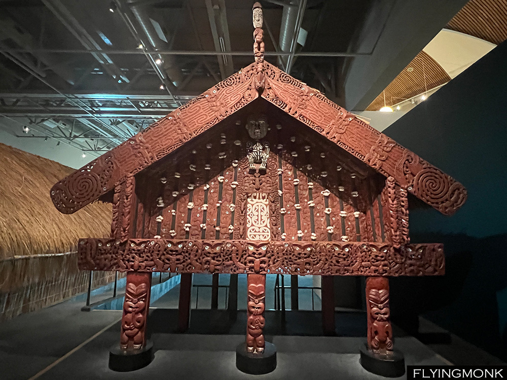
In Whakarewarewa village, Rotorua guides descending from the chieftains who settled the clan in the area conduct village tours explaining in detail their traditions. Their village lays on boiling ground that spits steam and scalding water in transparent blue pools. Living for many generations on this dangerous ground Maori learnt how to use this immense underground energy for heating and cooking. Also they perform a traditional haka and several other dances and songs. In Māori villages, carved houses play a central role as meeting places and sites for ceremonies. A wharenui, meaning “large house” in the Māori language, serves as a communal gathering place. Typically located at the heart of a marae, or Māori meeting ground, these structures are often called in English meeting houses .

Also known as whare whakairo that means “carved house,” their current style emerged in the early to middle nineteenth century. Wharenui have elaborate carvings both inside and out, featuring stylized depictions of the iwi‘s ancestors. The specific style and motifs used in the carvings may vary from tribe to tribe. During formal Māori gatherings the visitors are received with a ceremonial hongi, where noses are pressed together in greeting. Recitations in Māori language and traditional songs are common as well as cooking of food on preheated stones in earth ovens, known as hāngī that add a cultural significance to the meal.

Māori society was formed by clans or iwi and is divided into three main social classes, or “grades”, that determine rank and status. Rangatira is formed by the chiefs and ruling families, Tūtūa were the commoners and Taurekareka were the slaves. A Taurekareka can marry a Tūtūa and upgrade its status but further up it was very difficult to reach. Even today most if not all Maori politicians are part of the Rangatira class.

Traditional Māori beliefs are deeply rooted in Polynesian culture, encompassing concepts like tapu (sacred) and its opposite, noa. Certain objects, entire areas, or buildings are considered tapu and require a special ceremony to convert them to noa. For example a purification performed during fishing ensures that the catch will not have tapu and can be killed and eaten. An important concept in the society is mana that is associated with authority and prestige. Also Maori have the concept of wairua that means spirit that shape most of their rituals. However nowadays most of the Māori adhered to a form or another of Christianity.

On February 6, 1840 representatives of the British Crown and Māori chiefs signed the now famous Treaty of Waitangi aiming to establish a partnership between the two parties that would ensure the protection of Māori rights while facilitating British colonization. Māori chiefs agreed to cede sovereignty to the British Crown in exchange for protection and equal rights as British subjects. Also the treaty guaranteed Māori ownership of their lands, forests, fisheries, and other possessions. However, disputes arose over the translation and understanding of this second article, leading to widespread land confiscations and grievances.

The Waitangi Tribunal was established in 1975 to address these grievances and facilitate the settlement of Māori claims related to the treaty. Twenty years later Waikato–Tainui was the first iwi to secure a Treaty of Waitangi settlement with the Crown, in regards to land confiscations of the 1860s. It was remarkable victory for the Maori and the agreement included a formal apology from the Crown, symbolizing acknowledgment of past wrongs. Queen Elizabeth II herself signed the Act that enshrined the agreement into law during a state visit in 1995.

Currently about 17% of New Zealand population self-identifies as Maori and about 71% as Pakeha, white New Zealander, but it is estimated that the large number of intermarriages that existed in time put the number of Maori in the society at around 25%. The official language of New Zeland is Maori. The language is similar with the dialect from Cook Islands, Samoa and Hawaii. Another official language is the Maori sign language while English is the de-facto language, the government language, a sort of lingua franca but NOT an official language of the country. The last decades saw a shift towards mainstream for the Maori language and traditions that were frown upon for more than a century till around 1970. Maori language is currently mandatory taught in school and all kids, even if they end up not being fluent are able to understand with their Maori friends. However English is spoken by more than 95% of the population.

The Ring was forged within Sammath Naur, the Chamber of Fire, deep within Mount Doom, the volcanic stronghold of Sauron who projected into its essence his formidable might. Mount Doom, the heart of Mordor is Tongarino National Park’s Mount Ngauruhoe, a lava-covered conic volcano considered sacred by the Maori. In their tradition, Mount Ngauruhoe, whose name translates as “peak of Uruhoe,” pays homage to a slave sacrificed by the high priest of the Arawa canoe, to procure mana (spiritual power) for a sacred fire supposed to arrive from Hawaiki.

On a more mundane tone both Mount Ngauruhoe and Mount Ruapehu could be admired from the famous Alpine Crossing, a 20 km/6-8 hours hike in Tongariro National Park considered the best hike in New Zealand. But the weather that looked great the previous evening conferring great views over the Mount Ruapehu turned cloudy and we barely been able to see only occasionally and only in the morning the top of some surrounding peaks after which the clouds descended covering everything around. The hikers descending from the top came drenched straight from the cloud which veiled them completely in a blanket of drops and advised us not to continue.

So instead of one long hike we settled for two shorter ones. Soda Springs Track, 6 mile-return, the first part of the Alpine Crossing was covered in atmospheric, but not so wet clouds. The trail goes through a valley covered by huge lava boulders rolled there from the last eruption of Mount Doom/Ngauruhoe. No, not the one from the movie though…

Mount Doom/Ngauruhoe is considered a separate mountain but it is actually the second vent of Mount Tongariro. It first erupted 2500 years ago and more recently in 1977.

For the second hike we picked Silica Rapids, a hike to a river covered in silicas that winds down through the valley. The hike starts from the main road and can loop towards the village.

But again with limited time we set for a return hike (3 mile-return) and more exploration on the road that climbs the mountain to the ski resort built on top.

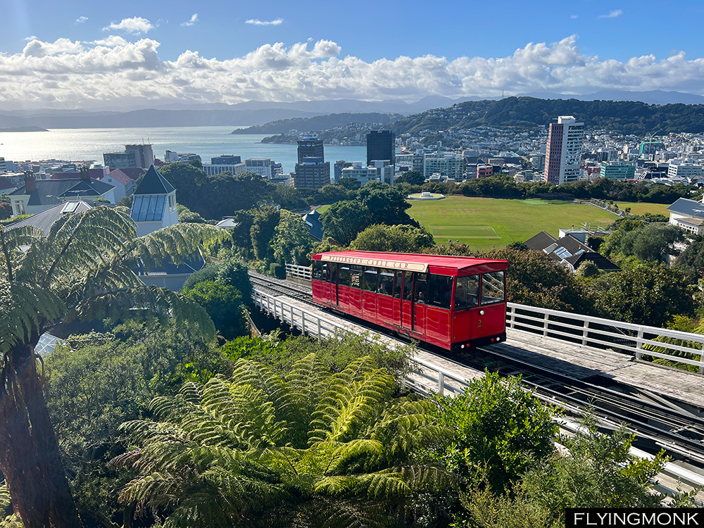
Wellington, New Zealand’s capital, is the country’s third largest city with about 200000 inhabitants. It’s a quaint place in accord with the rest of the country. We came here less for exploring a New Zealand city but to visit its fascinating museum Te Papa, the National Museum of New Zealand.
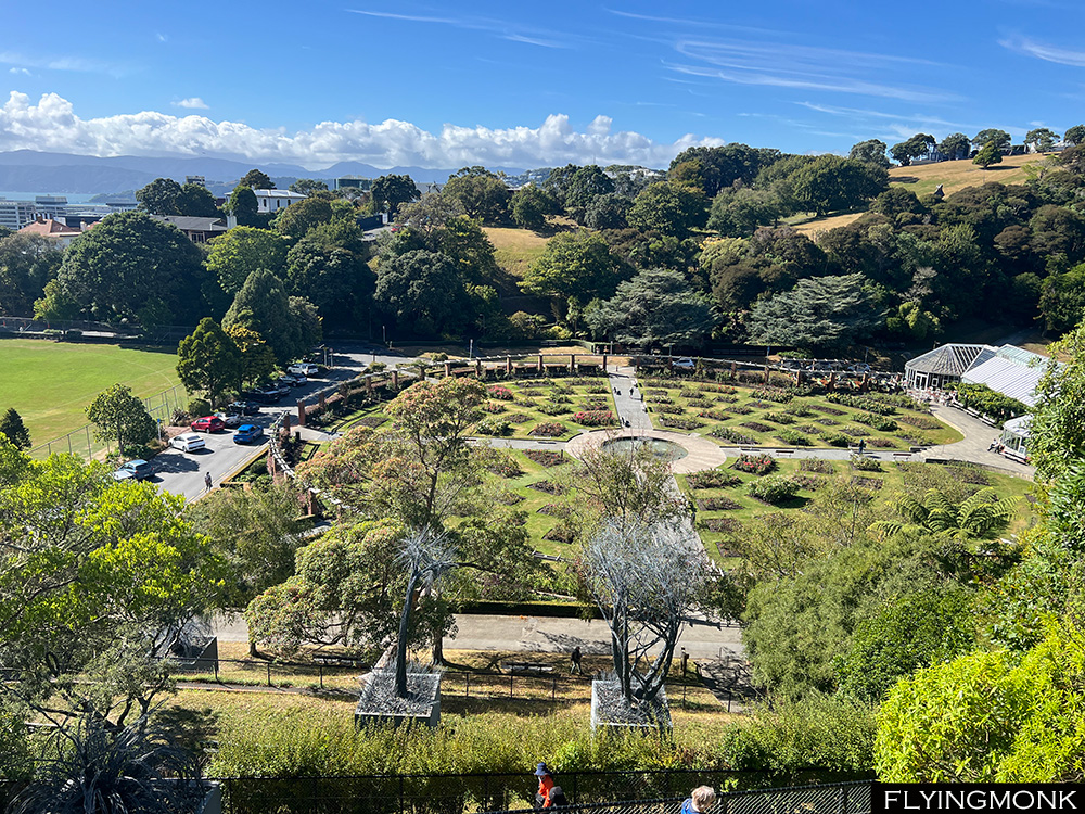
But as long as we were here we took the cable car and viewed the city and its harbor from above. From the Kelbum suburb we descended the hill through the Botanical Garden where we witness how crews were felling a gigantic dry tree, removed piece by piece by … helicopter. They were cutting one piece, anchor it, the chopper would lift it and dispose it a bit further down. As the garden attendants were saying, this would chew a big chunk of the yearly tree budget.
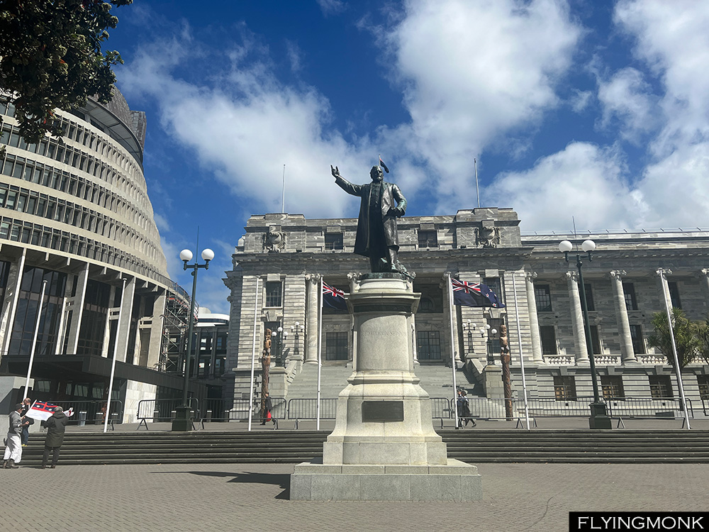
The New Zealand’s Parliament can be easily visited by a tour or simply you can walk to the gallery and watch the ongoing session debates session. But it took quite a while to grasp the kiwi accent…
Te Papa offers a great first lesson in Aotearoa culture. The Maori name of New Zealand seems to stem from the first word that was pronounced when the first migrants saw the island while sailing in the Pacific. It appeared to them as a “long cloud” – Aotearoa.
The first settlers of the land we know today as New Zealand migrated from Polynesia and became the Māori. The lineage of these ancestors traces back 5,000 years to indigenous peoples in Taiwan. From there, Polynesian people dispersed across a vast area, including Tonga, Samoa, Tahiti, Hawaiʻi, Easter Island (Rapa Nui), and eventually New Zealand.
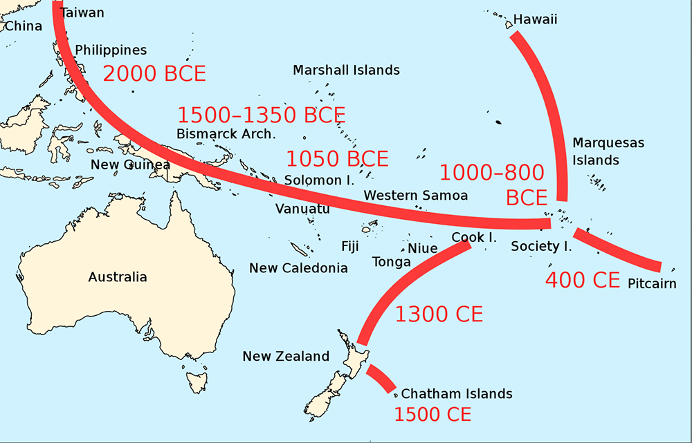
It is not known precisely when Maori settled in Aotearoa but the Maori oral tradition mentions a grand migration between 1320 and 1350 that originated in Hawaiki, that is associated with Tahiti. In the Māori mythology, Hawaiki has its special place. It is known as the realm where Io, the supreme being, shaped the world and its first inhabitants but also it represents the ultimate destination of each individual soul after death.
Some researchers mention of a possible early Māori settlement in the north island between AD 1250 and AD 1275. In any case it is known that in 1315 Mount Tarawera viciously erupted changing the landscape of the north island. The main settlement period is believed to have occurred in the decades after the Tarawera eruption. There are also speculations that Maori seafarers have been the first humans to discover Antarctica.

Our time in New Zealand’ south island was coming to an end. Today was our tenth day in the south island and we barely scratched the surface saving only 5 more days for the north island. On the way from Timaru, we stopped a bit in Christchurch and continued on the east coast towards Picton. The spectacular drive follows almost in its entirety the shore, an almost 5-hour drive towards the ferry.

Picton’s harbor is surrounded by peaks. The Cook Strait that separates the two islands is formed on its southern side by a collection of fjords from where sailboats or tugboats came out in the caressing sunset. It took more than 90 minutes to reach the end of the fjords and entered the open sea towards the north island. The entire crossing took about 3 hours and ended up in Wellington harbor in close proximity to the city center.

In Māori legend, the North Island, named Te Ika a Māui represents Māui’s fish, while the South Island named Te Waka a Māui symbolizes Maui’s waka (canoe). The waka is anchored by Stewart Island-Rakiura translating as “Māui’s Anchor Stone.” . As the story goes, Māui, armed with an ancestral jawbone hook, hauled a colossal fish from the depths of the sea with the help of his brothers. Together, they hoisted the fish to the surface, forming the South Island, which served also as their vessel.

According to the Ngāti Porou tribe of the East Coast, their sacred mountain, Hikurangi, was the first part of the fish caught by Maui to emerge from the water. They believe that Māui’s canoe, Nukutaimemeha, became stranded on Hikurangi and remains there in petrified form.


The powerful wind that blew yesterday in Hooker Valley was a sign of a long announced incoming storm. We hoped that the storm front will move quickly but it was there to stay and the morning Twizel was covered by clouds. On the top picture is the previous day’s Aoraki view and on the bottom picture is the today’s view.

The menacing storm clouds were in deep contrast with the emerald color of Lake Pukaki’s surface lit by the sun rays. So we had to bail out of other hikes around Aoraki and we settled for a very domestic walk in Twizel when somehow the sun was able to shine through the clouds in spite of the neighboring storm.

For the second part of the day we went for Mount John Circuit by Lake Tekapo, a 6 mile hike with magnificent views over the lake and its islands. According to Māori lore, Lake Tekapo, or Takapō, is related with two iwi chiefs who, rushing to depart by night from the lake were caught by the rising sun and somehow transformed into two pillars that now guard Lindis Pass’ entrance. The word “Takapō” comes from the Māori words “taka” (sleeping mat) and “pō” (night), evoking the notion of hurried departure under cover of nightfall.

The hike by the lake climbs all the way to the peak of the hill that has on top an astronomic observatory and continued from there by descending towards the lake. There are no other legends on the path, just great beauty. Lake Tekapo town was packed with tourists who were pacing a beautiful promenade by the lake, a charming walk that ends by the Church of Good Shepard, dedicated “to the glory of God and as a memorial to the pioneers of the Mackenzie Country”.


While moving in the southern island you gyrate around Aoraki/Mount Cook. It’s always there but somehow unreachable. To come close to it you have to go around the entire western mountain chain and drive the last leg from Queenstown along the celestial blue surface of Lake Pukaki.

And if the weather cooperates Aoraki would shed its mysterious veil and you could see it from far away in its full splendor. The most beautiful hike towards the peak is Hooker Valley, an 8 miles/3 hours return hike. It crosses three times Hooker River following along its waterbed on three suspended bridges that sway precariously in the gusty winds.

It was sunny but the wind was ferocious swinging the bridges and scaring the hikers who felt their wobbly stepping on the bridge unsafe. The clouds seemed to stand still on top of the adjacent peaks in spite of the blustery wind but the forecast mentioned an incoming storm that was supposed to be bring rain the next day. So the wind was just the preamble of the menacing storm.

However the wind or the incoming storm did not stop anybody’s hike towards the peak. The trail is quite easy, the elevation gain less than 300 meters, and as a result it was the most crowded trail I ever encountered anywhere even if you count the Manhattan’s Central Park’s alleys. It seemed that everybody and all their aunts were there. However the hike was rewarding even in the tempestuous wind with Aoraki glittering in the sun peeking out of the landscape for the entire hike. We would have liked to continue the hike even further following the contour of its base lagoon filled by ice floats but the wind whispered that is better to give up and just sit at the base of the mountain and enjoy its splendid view furtively offered. It was a gift that will soon be veiled by the incoming storm.

According to the ancestral legends of the Ngāi Tahu iwi, Aoraki and his three brothers trace their lineage to Rakinui, the Sky Father. The siblings descended from their celestial realm in a majestic canoe to visit Papatūānuku, the Earth Mother, and embark on an expedition across the vast expanse of land and sea. During their voyage, tragedy struck as their waka (canoe) foundered upon a treacherous reef, forcing the brothers to seek refuge atop the vessel’s upturned hull. Their fishing endeavors proved fruitless and hunger soon gnawed at their spirits compelling them to contemplate a return to the heavens, to the sanctuary of their father, Rakinui.

Aoraki had to initiate the sacred incantation to launch their colossal waka back towards the cosmic expanse, but in this critical moment, his courage faltered, and he hesitated to utter the final words that would liberate them from the earthly realm. Exposed to the merciless chill of the southern winds, Aoraki and his two other siblings turned into three majestic towering mountains and the canoe itself metamorphosed into the South Island.


There are lots of things to do in Queenstown and our original plan was to climb Ben Lomond Peak but that would have taken the entire day. After a lot of back and forth we set for a more down to earth hike around Moke Lake, a 3 hours loop in order to have time and do some other things during the day.

From Moke Lake we continued north towards Glenorchy following the shore of Lake Wakatipu. There are several choices of hikes on the way but with, again, limited time we chose Bob’s Cove Lookout.

In Maori language, Bob’s Cove is called the “sacred pool”, Puna Tapu, and it was an important place for ceremonies. The hike is not long following the contour of a peninsula that you have to circle around only because it is not trail going straight up to the viewpoint that is actually very close.

For the English, Bob’s Cove was named after Bob Fortune, a commander of William Rees’ boat who was an explorer, surveyor and one of the first settlers in the Otago province of New Zealand. He is considered the founder of Queenstown and his statue adorns the pedestrian area of the town. The cove was looked after and always used by Captain Bob Fortune who hid his boat from storm inside its protected shores.

We found Thomas’ Little Paradise on Atlas Obscura and we were the only visitors. A real tiny piece of paradise created by this Swiss with his own hands in the place where he moved 40 years ago. The beautiful and diverse garden impeccably maintained has lots of sculptures created by him. The entire property lays smack on the 45th parallel of the Southern hemisphere that is marked with a line made out of stones.

His house is a work of art as well completely built and decorated by him with log carved furniture and flooring, weavings and wall paintings that we wished we knew about before we booked our Queenstown’s apartment.

But more than anything Thomas is quite a character whom we spent more than one hour chatting about the way he sees the world, NZ and American politics all with a world view upon events. We wished we could stay and chat longer but the day was going toward sunset and we had still to drive to Glenorchy, 20 km away.

And finally we made it to Isengard, where the Númenóreans in exile built the fortress meant to protect Gondor’s northwest border. Actually Glenorchy/Isengard is a charming place where Daart River flows into Lake Wakatipu. But the heavy clouds brought a menacing look to the Lord of the Ring’s citadel location and we had to leave fast not to get drenched but it ended up not raining at all. Daart River is the conduit towards Te Koroka, a mountain in Mount Aspiring National Park with lots of pounamo, the jade-like greenstone coveted by the Maori and abundant in this part of Aotearoa, as the Maori call that land we know as New Zealand.

There is only reason that may make you want leave New Zealand’s west coast: the sand flies. Small gnats that will land anywhere on you and pinch almost imperceptibly. You may not even notice them sometimes but you will wake up in the middle of the night and scratch yourself to oblivion. And the bites will stay there for weeks and still hurt. In Maori the sandflies are named namu and are a species of blackflies. So be aware and cover yourself if you don’t have any insect repellent.


With limited time in New Zealand you always have to compromise between destinations. There is a large number of day-hikes to chose from in Milford Sound and with the time needed to cover the distances we were able the previous day to squeeze only the Key Summit hike besides the mandatory cruise on Milford Sound.

And we were able to do this only by spending the second night in Te Anau where is a great bird conservation park where we were able to see the almost extinct Takahe. Otherwise lots of sheep, pig, cow, deer and lama farms on the road to Queenstown. New Zealand is full of farms everywhere you drive.

The drive from Te Anau to Queenstown takes about two hours with no stops. After arriving in town we went straight to the Remarkables paid road that takes you in steep hairpins all the way up to the ski lifts base. From there the hike climbing partially the ski slopes takes you to Lake Alta, an eye of emerald water surrounded by dry metamorphic rocks with intricate design pushed up by the earth pressure.

While basking in the tranquility of the serene environment of the lake we were rattled by a helicopter sound above. In spite of the deafening noise it was interesting to watch how the “kiwis” were building a new ski lift, the entire work done by helicopters hauling materials. A country with too few people, 5 million over an area larger than UK, but with good technology.

Queenstown sits on the shore of Lake Wakatipu known in the Maori legends as the “hollow of the sleeping giant”. It’s a legend about the secret love between Matakauri, a young warrior, and Manata, the daughter of a Māori chief. One night, Matau, a giant taniwha, sort of a troll, kidnaped Manata and hid her in his mountain lair. This was the chance of Matakauri who went after Matau, killed him and rescued and married the poor girl.

The body of the dead Matau troll burned a hole in ground soon filled by water, forming the large “S” shaped Lake Wakatipu. Matau body has his head at Glenorchy and his feet at Kingston while Queenstown sits on the knee of the giant. Matau’s heart is the only part of him that still exists, and it beats in the lake, causing the water level to rise and fall by 20 centimeters every 27 minutes. This phenomenon is called a seiche, which is caused by wind and atmospheric changes. Some say that the Hidden Island across the lake from Cecil Peak is the still beating heart of the giant Matau.


The southern part of the Southern island is in a way the climax of a trip to New Zealand. Fjordland’s beauty is unmatched. The drive through Fjordland to Milford Sound it’s considered the most scenic drive in the entire country and there are so many places to stop that you wonder how you would be able to see everything. In order to have time to explore Fjordland we decided to spend two nights in Te Anau and it proved a wise decision not adding two more hour drive to Queenstown.

From mind boggling views of peaks among peaks hanging from the sky, to magnificent waterfalls, to endless plains squeezed by mountains, to lakes perfectly reflecting the surrounding peaks, to inviting tracks winding to surrounding tops and a mysterious tunnel the road to Milford Sound is a collections of places so alluring that you feel that you’d never have time to reach its end.

In 1973, John Williams, a geology student – now professor – at the University of Otago, inspired by Tolkien’s “Lord of the Rings” suggested a list of new names for places in the Fjordland. Among his naming was Mt Gondor, Rivendell Pass, Westernesse Pass and Mordor Peak. He also renamed two peaks, Sauron Peak and Isengard Peak. The park administration rejected the whimsical suggestions as not being in tune with their naming scheme.

Fast forward some decades here comes Sir Peter Jackson labeling the surrounding peaks “the Misty Mountains” and …the rest is history. Nowadays few visitors would remember the English or the Maori names of the peaks but all will know how the places are named in The Lord of the Rings.

After a longer than planned drive we finally reached Milford Sound harbor in time to board one of the numerous boats that cruise all the way to the treacherous Tasman Sea. According to the legend Milford Sound was crafted by the divine hands of an atua (demi-god) named Tu-te-raki-whanoa. With his toki, a sort of an ancient axe, and the power of karakia, (prayer), he carved out the sharp valleys that define the scenery today chiseling the rugged cliffs that surround it.

In Maori. Milford Sound is named Piopiotahi, that means “only one piopio”. A legend mentioned the famous local hero Maui who, on quest for immortality for mankind, met his demise at the hands of the goddess of death, Hine-nui-te-po. Maui’s partner, a piopio, a now-extinct small endemic bird, lamented his loss, singing a mournful melody in the Milford Sound from where it came the name of the place.

Captain James Cook twice sailed in 1773 by Milford Sound but failed to discover its entrance so never been able to witness its grandeur.

Part of the famous Routeburn Track, a 32 km track through an alpine landscape of remarkable beauty, Key Summit is a 3 hours return track to a peak on an alpine plain with supposed remarkable views of Darran peak and Lake Marion.

It was a great sunny day in Milford Sound but while we started to hike the track the clouds started to gather and soon we were hiking inside an atmospheric fog till we reached the alpine shelf. We navigated through mysterious forests covered in moss to the viewpoint from where we were supposed to have the magical view but all we could see was complete fog/cloud.


The two large glaciers, Franz Josef and Fox fence the north side of the extensive Mount Aspiring National Park. According to Maori legend, Mount Aspiring is the resting place of Haast, a mythical bird with supernatural powers. It is believed that the mountain holds spiritual significance and is a connection between the earthly and spiritual realms. Māori believe that Mount Aspiring is the younger brother of Aoraki (Mount Cook).

The Māori name for Mount Aspiring is Tititea, which means “peak of glistening white”. The mountain was named Tititea by the Māori after a chief of the Waitaha tribe, who were the first people to settle the South Island.

According to the Maori tradition, Tititea, like all main mountains embodies the spiritual essence of Raki and Papa. It serves as a sacred conduit to the ancients in the traditions of Ngāi Tahu, the present tribe that has kahu over the area, the guardians of this land. The peaks’ towering presence is visible from various southern vantage points, its significance deeply woven into the creation narratives of the iwi (clan).

While commonly known as Mount Aspiring to Pākehā (New Zealander of European descent), Tititea carries multiple identities evoking its snow-capped peak, or under other names connecting into other traditions and narratives of the successive iwi who have inhabited these lands.

Driving through Mount Aspiring National Park is both spectacular and frustrating. The views are splendid making you stop continuously to take pictures. It’s a parade of amazing panoramas of white peaks, pristine rivers and quaint lakes. The frustrating part is that there are few day hikes, and even those are very short. The mountain is full of huts and there are lots of long tracks where you would overnight in these huts. But for this you need a lot of time and not a two-week-rushed-travel.

So we resigned ourselves to hike these short tracks of several spectacular waterfalls and the Blue Pools where unfortunately we found the bridges closed following recent damages from storms. But we were content with the stunning drive within Mount Aspiring National Park, probably the most beautiful and rewarding from all Southern Island drives.

After leaving Haast River the road follows the contours of Lake Wanaka and Lake Hawea ending in the town of Wanaka, a fancy resort full of crows, water activities, beaches, helicopter rides, – there are everywhere in New Zealand -, restaurants, coffee places and ice cream parlors. The quietude of Mount Aspiring is totally shattered in Wanaka.

The town is on the shore of Bremner Bay that has a nice manicured promenade from where you can admire the glitzy condos on the shore and the boats moored in the bay.

On the other end of the bay, towards Glendhu Bay is the most photographed tree in New Zealand that is so popular that it has its own Instagram hashtah.


Kā Roimata o Hine Hukatere is the Maori name of the glacier better known as Franz Josef Glacier. It stretches for 12 kilometers in Westland Tai Poutini National Park on New Zealand’s South Island. Its European name, Franz Josef Glacier, was attached by the German geologist Julius von Haast in 1865, in honor of Emperor Franz Joseph I of Austria, a weird name association for this part of the world. But the first European account of the glacier was recorded in the log of the ship Mary Louisa in 1859, marking the beginning of its exploration and recognition in Western literature.

Legend has it that the Māori name, Kā Roimata o Hine Hukatere, translates to ‘The tears of Hine Hukatere.’ According to oral tradition, Hine Hukatere’s lover, Tuawe, perished in an avalanche while climbing the mountains with her. Overcome with grief, Hine Hukatere’s tears cascaded down the mountainside, eventually freezing into the glacier by the compassion of Rangi the Sky Father.

Not far from Franz Josef Glacier is another glacier, Fox Glacier, which the Maori legend says is Tuawe’s resting place. Both glaciers are enveloped by the pristine wilderness of Te Wahipounamu, a UNESCO World Heritage Site. Actually, this wilderness is the allure of the place more than the glaciers themselves. You hiked through the rainforest to reach the base of both glaciers, through gigantic ferns and moss-covered trees and at one point you can see the bottom of the glaciers behind a huge palm or fern tree. The glaciers of Patagonia or Iceland I’ve seen before are all in a desolate landscape with almost no trace of vegetation.

The Waiho River originating from the terminus of Franz Josef Glacier increased its level in a 2022 storm flooding the entire area. Unfortunately, nowadays, with the entire track washed away, the park closed the access to both glacier bases, keeping all visitors 3 km away.

An interesting walk of the area is on the short Minehaha Trail where glowworms hang on rocks in the humid climate. The night walk of the trail is supposed to be a spectacle of tiny dots of light, similar to what we saw in Dell/Hokitika but this time spread on the entire trail. But we had to be in Haast in the evening so we walked the trail during the day. These tiny strings from the above image are the glowworms. They eat midges, mosquitoes, and moths that get stuck on their sticky threads. The glowworm lures the prey by generating through bioluminescence a tiny light on its tail. This glow is actually a byproduct of excretion.


Close to Greymouth, on the western coast of New Zealand, Punakaiki is a spectacular limestone formation named this way for their stackable appearance. The rocks may have been developed in time under the sea level and pushed up later by tectonic movements. The geological marvels of the pancake rocks crafted from lime-rich remnants of deceased marine shells let the sea waves pass underneath and explode in spectacular blowholes.

Their creation commenced approximately 30 million years ago, as lime-rich fragments of deceased marine shells gradually accumulated on the ocean floor, laying the foundation for these distinctive pancake-like structures. But in Maori legends, they may mean “spring of food”, a place of abundance. Or the name may be even a transliteration of the western term of pancake rocks…

The short walk around the Pancake Rocks can be extended with the inspiring hike of Punakaiki – Pororari River loop. Walking back from the carpark towards the Pancake Rocks you stop on the way to explore the Punakaiki Cave, right off the road. Its entrance is lined up with nikau palms in front of a huge cliff wall which is usually dripping with water. Inside there are corridors for more than 150 meters to explore if you have time and a torch.

The Punakaiki-Porora River loop together with the visit to Punakaiki Rocks is a bit shy of 9 miles crossing a mysterious rain forest ridden with gigantic ferns among contorted trees with moss hanging from their branches. This is the realm of Tana, the god of the forest.

Tāne Mahuta, revered as the Lord of the Forest, holds a significant place in Māori lore and history. As the eldest of six siblings, Tāne grew weary of dwelling in perpetual darkness, confined between his celestial father, Ranginui, and terrestrial mother, Papa-tū-ā-nuku. Driven by a desire for illumination and freedom, Tāne resolved to separate his parents and, in this monumental act, ushered forth the world of light, known as Te Ao Mārama, which we inhabit to this day.

Just a bit further up the road, on Truman Trail you can reach an atmospheric beach where springs merge in small waterfalls pouring from the rain forest into the Tasman Sea.

Punakaiki Beach invites you to explore it and take pictures under the gigantic and precarious caves formed by the powerful waves. The rock walls washed by the high waves are covered in minuscule clams or tiny snail shells, looking like the intricate work of a meticulous artist, layers of shells that will create in the distant future more stratified rocks.

Back in Hokitika for dinner – finally able to come back in time to find the restaurants still open – we stroll in the dark to Dell one of the few location on the southern island were you could see glow worms. The tiny dots of light in the image bellow are the worms glowing in the night doing their best to attract the pray. But more about them in a future post.


The enigmatic realm of Kura Tawhiti, known to many as Castle Hill, sits in the middle between the east and west coast of New Zealand’ southern island. Its otherworldly terrain of limestone boulders, sculpted by time and nature into shapes seems reminiscent of ancient castles. It’s an inspiring place named by Dalai Lama the “spiritual center of the universe”.

To the Maori tribe of Ngai Tahu, this place holds profound historical, spiritual, and cultural significance. Known as “Kura Tawhiti” in the Maori tongue, which translates to “treasure from afar,” Castle Hill is revered as a sacred site. In Waitaha lore, the area is known as ‘te Kohanga’ or the ‘birthplace of the Gods’.
In the Polynesian tradition the origins of humanity is deeply intertwined with the natural world. The primordial parents, Ranginui (the sky) and Papatūānuku (the earth), gave birth to Tāne, the forefather of humanity. Tāne created a woman named Hineahuone from the earth symbolizing the feminine essence arising from the soil. Hineahuone bore a daughter from Tāne named Hinetītama. She served as the guardian of the boundary between darkness and light, dusk and dawn, revered both at sunrise, with the emergence of daylight, and at sunset. These figures are revered as the ancestors of humankind and no better place to worship them as in Castle Hill.

Kura Tawhitil served as an astronomical observatory for predicting seasons and weather patterns, with a considerable population migrating from the coast during summer to tend to the sacred kumara vegetable. The limestone geology, believed to be built up by ancient creatures since the dawn of time, was considered sacred, with prominent leaders like Rakaihautu buried here, the first to explore and inhabit the South Island around 850AD.

When you hike in Castle Hill area you feel like in the land of Rohan. The Lord of the Rings’ shooting location was not here but a bit to the south in Mount Sunday, but the landscape is reminiscent of the Tolkien’s imagined Middle Earth. However other movies had scenes shot here.

Around Castle Hill the mountains are rocky and dry. Its grass is deep but yellow and is barely any other vegetation like the wind terrified any trace of a plant that would have tried to stick out. But if you cross the pass the orographic effect takes over and the vegetation changes radically morphing into a temperate rain forest. Its first sign you find if you hike to several falls in Arthurs Pass, Bride’s Veil and Devil’s Punchbowl, the last one a superb waterfall that no image would make it justice.

And if you are hungry or like us afraid that all kitchens will be closed when we’d arrive in Hokitika, share a meal with Smeagol and other wizards surrounded by an incredible amount of shlock in the Otira Stagecoach Hotel.


In Polynesian folklore, the figure of Maui holds significant prominence.. Either as a folk hero who brought fire to the world, the one capable to slow the sun, or as a demigod Maui represents a central figure in the entire Pacific Polynesian culture. In the southern island of New Zealand the legend says that Māui cast a colossal giant into the ocean and buried him beneath a mountain on Banks Peninsula.

After an entire winter while the giant lay dormant, as summer approached, he woke up from his slumber and started to stir, causing the land to crack and form Akaroa Harbour. Trying to restrain him, Māui continued to heap earth atop him but the giant would awaken every summer creating new lakes and bays in the peninsula. I drove the road from Christchurch airport through the middle of this turbulent peninsula in this otherworldly landscape towards Akaroa till the clouds and dusk veiled the land in a bluish hue.

Maybe the giant still stirs under the ground causing the powerful tremors that affect Banks peninsula, a very earthquake prone area of Southern island of New Zealand. The 2011 Christchurch earthquake’s signs still scar the city. Its newly built center is all steel and glass, modern and minimalist, lifted from the dream of an architect that could design unhindered by an inexistent old. Some tall buildings, chipped and cracked, are still waiting to be demolished and a new cathedral is still in the process of being rebuilt. Meanwhile I was able to find a stretch of lower old houses full of cafes and restaurants saved somehow from the giant’s wrath that still offers a whiff of the old times .


Tasmania was an after-thought. Actually it came as a piggy back to a better planned two-week travel/hike in New Zealand. For family reasons I wanted to come early in this part of the world, before arriving in NZ, to get adjusted to the local time and the local driving – on the left side. And hiking all days is the perfect receipt of avoiding getting COVID in New York…

I read a bit and also spoke with some Aussies about Tasmania and all I got was that it had a great drive on the Eastern Coast, from Hobart all the way north. But when I started to read in detail, I realized that my 5-day trip would not suffice. The island seemed extremely interesting and I was more and more puzzled why people were not raving about it. I found some blogs a bit more detailed but still I could not gauge the exact number of days needed for covering all its national parks.

So I upped my planned stay in Tasmania from 5 days to two weeks, thinking that I would spend a bit more than a week in the island and the rest of the time in Australia. I’ve been in Australia six years ago, so where should I go now? Perth was too far, Darwin too hot, Adelaide for hopping to Kangaroo Island – too complicated and Brisbane way too big of a city. So I started my hikes in Tasmania and the more I traveled, the more interesting locations I found to spend time and less days were left in my two weeks allotment to spend in Australia.

And so tramping through the national parks of Tasmania I ended up using all two weeks discovering this amazing land, once discovered by Abel Tasman for the Dutch and later by so many unfortunate inmates populating the British gulag of its time. I loved it so much that I decided to spend all my 14 days in Tasmania and fly from Hobart to Christchurch, NZ with the mandatory airline stop in one of the two big cities of Australia. But searching for flights I realized that all connecting flights would have arrived in Christchurch after midnight where no rental cars or hotels were available and spending the night in the airport did not make sense. So, in the end I decided to stop for one day in the Sydney and get a next day morning flight to New Zealand. I got off the plane and started to walk in a sultry 98F Sydney’s botanical garden, its boulevards crisscrossing through parks and green thumbs all the way to Darling Harbor, continuing on its commercial streets, galleries and bridges, starting and ending in front of the magnificent opera house and remembering the great time I spent here in an era that seemed like lifted from a dream where the word “pandemic” was not yet known by the world.

The first I noticed was the silence. It’s strikingly quiet in Hobart. I was on streets lined up with houses and I could not hear a whisper. It seemed that everybody was sleeping.
Hobart like all Tasmania seems the epitome of chill. It seemed like a remote realm undiscovered by tourism in spite of relatively numerous independent travelers and hikers. This lack of tourists stems probably from the lack of accommodation offered in some of the destination, like Cradle Mountain where is hard to get a reservation of any kind, so a bunk bed in Discovery Park is the go-to for many hikers. There are very few tourist buses that you encounter on the way. The roads are mostly paved, all in very good condition. On any dirt road a regular car would pass with no issues.
The relaxed atmosphere extends to restaurants that close their kitchen around 7:30pm and chances to remain not fed for the day are tangible if you arrive late. I learned this early schedule the hard way; my first nights I had to beg in shock for a dish of whatever they had left if I was even a bit late after the kitchen closed. And that may have meant 7:35pm. However you still have a beer of other drinks late. Store and tourist places are closing around 4pm and everybody seems to enjoy this life style and chill with friends or at home, minding their own business because tomorrow is another day. But this gives a pleasant vibe to the people who are cheerful and extremely polite, always welcoming you with a smile.
In the morning cafes open early and lots of locals hang out having breakfast and chatting while others walk Hobart’s streets going to work. But few restaurants, if any in Tasmania countryside offer breakfast. In Hobart, the restaurants stay open a bit later but is still better to have dinner early to play safe.

This was my last night in Hobart. I came in Tasmania planning a fast trip of several days and after two weeks I was regretting that I had to leave. My pensive mood was shared by a red moon that rose over the city, an obvious but not much celebrated event, noticed mainly by the tourists who were hanging out late in the harbor.

Bruny Island – two of them actually, North and South – is long. The crossing ferry tickets were purchased online and showed while boarding the ferry with no scheduling required. The ferry runs very often and after a 20 minutes crossing you are again on land. The drive to the tip of the southern island to the national park takes about 70 minutes, part of it on a dirt road.

The lighthouse, the second oldest in Australia, offers every half hour a tour that is relatively OK with some great views from the top. There are also some interesting hikes around it if time permits.


But no matter how you try, with the time spent on crossing and driving through the islands, there is not enough time in a day to do more than one hike. And based on the local advice I chose the Fluted Cape Circuit following a trail climbing steadily through an eucalypt forest with razor grass bushes on the ground.

The Fluted Capes, 6 in total, confer amazing views over the ocean and the rocks around, spectacular drops plunging into the blue waters underneath. The drops are awe-inspiring and inviting but quite dangerous to approach them even for taking a picture.

The entire Fluted Cape circuit takes about 3 hours depending on the time spent admiring and photographing the capes.

It was a debate on the Internet about choosing between Maria Island over Bruny Island. And the winner is for sure Maria Island for its treasure trove of endemic animals that you encounter effortless there. In entire Bruny Island I saw only one rabbit on the penguins’ rookery but no penguins because they come out only after dusk. Except that lonely rabbit the only other beings I encountered were only tourists shuffled in buses, a thing that I did not see while traveling in Tasmania. The island proximity to Hobart makes it a target for tour groups.

Another notable aspect is that there is only one gas station in the island that takes only debit card and few food options.


The next day in Mount Field, the 16 km dirt road to Lake Dobson ends at the beginning of the hike through the alpine land. The tarn shelf has a collection of alpine lakes – tarns – and the hike skirts them on boardwalks or scrambling rocks. By each large tarn is a hut in an environment that in bad weather may be quite uninviting.

There are lots of tarns, many small and several large and you can walk and return the same way or simply do a loop following the contour of some larger lakes. The vegetation on the way, both the alpine and down the valley is impressive. The bushes are so diverse and unique with smelly leaves and flowers.

Many of the plants and trees are vestiges tracing back to the Cretacic, something that only Tasmania can offer that I was lucky to learn by meeting two biologists on the way. Even if the dry Pine Pencil Trees were once related to the American sequoia this happened about 125 million years ago…

The loop is long – 10 miles – and poorly marked but hard to miss, descending steeply through a brook’s channel in an environment that may offer some encounters with snakes.


After two days of perfect weather the Cradle Mountain returned to its habits and the clouds came low veiling everything around in a wet mist. So it was the time to leave Cradle Mountain and stopped on the way in Sheffield, a town of murals where I met Pedro, the traveling lama.

The drive to Mount Field makes for another long day of driving. Mount Field is a national park of waterfalls and tarns, small alpine lakes hung by mother nature close to the skies.

The 4.5 hour drive – it’s long to get to Cradle Mountain but it’s also long to get out of it no matter where you may go – was not the most interesting in spite of a collection of lakes on view. But driving down from the mountains helped improved the weather and the sun broke through the clouds.

Mount Field is a beautiful park and the waterfall trail is easy and very popular. It’s a 2.5 hour loop that passes three waterfalls, Russel, Horseshoe and Lady Barron, crossing on the way in a depth of a forest of very tall trees, an absolutely impressive sight.


After the yesterday’s hike everybody talked about getting it easier. To everybody’s surprise the weather held with blue skies and warm weather in a climate where the descending clouds rarely let you see the rock comb of the Cradle Mountain peaks.

A easy walk does not mean a short walk, and again at Dove Lake bus stop I started a hike/walk around the lake through forests of banksia and manuka bushes, the gem flower related to the famous honey.

The walk climbed to Wombat Pool where no wombats bothered to show up and climbed further till it reached its top from where descended onto Crater Lake and further towards Ronny Creek.


A short detour to Waldheim brought us to the first chalet built in the park by the charismatic Austrian traveler Gustav Weindorfer who settled here for good, inspiring lots of people with his enthusiasm for the mountain. On the way to Ronny Creek some wombats decided to make a show attracting the attention and the cameras of many tourists gathered on the boardwalks. The Cradle Mountain valley boardwalk was next, a relaxed walk in the middle of nature, with few other travelers on the a built-up boardwalk that stretches from Dove Lake to the Ranger station, a total of 3 hours one way walk.

But even with 9 miles of walk the day was easy so I had time for a visit to the Tasmanian Devils Conservation Project, right at the entrance to the park and watch the devils and the quolls at their feeding time.


Trails always start flat, inviting, seemingly a walk in the park. Nice lakes, flat paths and in Tasmania lots of boardwalks covered in wire netting that would arrest slipping but built to protect the fragile environment of the trampling tourists’ boots. And Cradle Mountain’s hikes are no exception. The mountain is crowded with tourists and served by a bus system that dropped me to Ronny Creek where I started the hike.

The weather was impeccable that is very unusual for this part of Tasmania: warm and blue skies with 100% visibility. I pondered upon various hikes in Cradle Mountain but I never contemplated to climb higher than Marion Lookout, a spectacular viewpoint over two lakes at the bottom and a large valley.

The Cradle Mountain summit hike is rated as “hard” on AllTrails and Komoto and I had nothing to prove anymore for hiking it. But as things evolve organically I spoke with some hikers who advised me to continue from Marion Lookout to the Flat track, a trail unfurling right under the peaks with a further descent to the lakes. But once arrived to the base of the Cradle Mountain summit, the path that can be easily distinguished in the image above was packed like a boulevard at rush hour. Everybody and their grandmothers was going to ascend the summit. The estimate time for the hike varied between 2-4 hours return, quite a margin.

It did not seem so bad, and the weather was perfect so I decided to join the crowds going for the summit. What few who started the ascent knew was that the hike up was actually not a hike but a climb and this became obvious after about half an hour of hiking up the mountain.

The well maintained path built in steps morphed in a hop over a collection of small rocks. But soon the small rocks became boulders and further up they morphed into huge slabs. At one point all you could do was climb one slab at a time and jump to another. Lots of people lost their enthusiasm garnered at the base of the summit and abandoned the trail.

Climbing seems to me like meditation. It’s a process where you empty your mind and the only thought is to the next grip. How stable it is? Can it hold? How about the next step on that indent in the rock? One grip, one step and another grip. You move up gently, swiftly, in no rush and no other thought bothers you. It’s not fear at all, it’s simply focus.

I used to free climb in the Romanian Carpathian for a while. Nothing technical, no ropes, climbing on tracks that were considered easy. But as easy as these tracks were any slip or failed grip would send you tumble in the best case scenario to a hospital bed if not to death. Since those times I fell in love with “bouldering” and I tried to do it every time I had the chance. But no matter how much I love it I did not expect to have to climb huge slabs for 90 minutes continuously.

The peak that is only 1505 meters was first climbed in 1937 by Henry Hellyer and a big cylindrical monument is built on top to commemorate the event. The peak has an extended top, covered by the same large slabs and people were all over it taking picturing and posting from the top.

The descent was as challenging as the ascent, if not more, and the long legs helped a bit. But it took almost the same time as the ascent and after about another 90 minutes with aching legs I reached the cabin at the base of the summit.

But the pleasant descent from the base of the summit towards Marion Lookout hid what I thought ended up being the worst part: the descent down to Dove Lake on a path fenced almost on its entirety by chains, a trail cut in very steep cutting rock. This was the most unpleasant part of the descent, even worse than the descent of the summit. But after 8 miles in 8 hours I finally found myself slumbered on the bench of a bus bringing me back to the Discovery Park at the entrance of Cradle Mountain National Park. The entire trail’s elevation gain was more than 900 meters.


It’s all good when you are driving on the Eastern Coast of Tasmania. Distances are not long and in two hours at most you reach another great national park. The road is known as the Great Eastern Drive. But when you reach St Helens it’s time to leave the East Coast and cross inland towards the other coast.

But luckily the road offers you lots of opportunities to stop and hike on the way and the waterfalls on the way to Derby make for great hikes. St Colombe can be reached after a short walk in a forest made out of the largest ferns imagined. You feel like in Cretacic if it happen for you to remember how it was in those times 🙂

On the way there are old pubs, like the Pub in the Paddock with its Drunken Pig, one of the oldest in Tasmania, a resting place for Harley bikers.

Further we passed Derby that feels that is ridden by mountain bikers that swarm in town coming from allover and continuing to Bridestowe Lavender Farm where unfortunately the lavender was already cut and all we got was some lavender ice cream.

The goal of the day was to arrive at Cradle Mountain that can be reached nonstop in about 5 hours drive from St Helens. But we kept stopping on the way in lots of interesting places including a tropical forest with myrtle trees as old as Gowanda, the ancient Southern continent that once encompassed all lands of the Southern hemisphere, now separated by oceans. And it’s a lot of talk, maps and explanations about Gowanda down here.


Rise with the sun to witness the mesmerizing spectacle of Bay of Fires’ explosion of colors, a moment of unparalleled beauty offered by the painted red hues of its rocks.

With dazzling white beaches, pristine blue seas and and boulders adorned with vivid orange lichen the Bay of Fires has earned global acclaim. Its enchanting landscapes evoke awe and wonder from every fortunate visitor. I took an almost 8 miles hike through the shaded path of the forest emerging from the sandy beaches from Skeleton Bay to Dora Point stopping to take pictures of the red rocks and touching occasionally sugar-white beaches.

Spanning a majestic coastline of 50 kilometers, the Bay of Fires extends from the captivating shores of Binalong Bay in the south to the iconic Eddystone Point in the north. Bay of Fires is at the end of the scenic Great Eastern Drive towards St Helens, a road that I kept hearing about when I searched Tasmania’s wonders.

But surprisingly wherever I read a short descriptions of Tasmania or spoke even with Aussies all they mentioned was the beautiful East Coast road and nothing about the parks themselves. Finally reaching the end of Tasmania’s Great Eastern Journey I spent some time to discover the hidden gems of Bay of Fires’ Coast from the serene shores of the Gardens to the picturesque landscapes of Jeanneret, Swimcart, and Cosy Corner but with most of the time spent along Binalong Bay.


While In Tasmania, if you ask about various national parks, the one question that comes first is if you have seen the Wineglass Bay. This iconic place is also the crux of the most interesting hike in Freycinet National Park, a 10 mile loop that climbs to an overlook from where you get a perfect view of the Wineglass Bay, probably the most recognizable gulf in the entire Tasmania.

Its crescent shape bordered by a white sand corola is enticing and even you have no intention or reason to walk its inviting beach, you will do it for almost its entire length of 1.5 km. A bit more than half an hour across the land there are the beaches of the Hazards guarded by red rocks, two bays separated by a bit of land.

Freycinet is Tasmania’s oldest national park. Named after the French explorer Louis de Freycinet who sailed through the area around 1800. The park is located on the breathtaking east coast overlooking the Tasman Sea and surrounded by the dramatic peaks of the Hazards. Its amazing views, the powder white beaches and its transparent blue waters make Freycinet the most photographed of all the national parks.

If that hike was not enough a short walk on the Cape Tourville’s boardwalk will bring in front of your eyes, the same Wineglass Bay in the distance surrounded by tall peaks. On the opposite shore red and orange rocks are the domain of the sea birds.

You can spend days in the park enjoying its charming beaches, like Honeymoon Bay, lazying in the sun or chilling with a cold drink in sunset. But if all you have is one day for the park, the Wineglass Bay-Hazards hike will remain forever in your memory.


Populated originally by the Aboriginal people of the Tyreddeme tribe Maria Island was also a convict colony of Australia. Convicts lived and worked here in two periods between 1825 and 1832 and later, in what is known as the probation station period – between 1842 and 1851. Also, the island was the gulag of its time for the Irish nationalists who participated in the Young Ireland Rebellion of 1848.

Structures from the these times are preserved in Darlington, a tiny hamlet with several buildings, actually the only preserved intact on the island. There are no cars in the island and if you want to explore further you may be able to rent a bike but walking is the better option.

From the 1880s, the Italian entrepreneur Diego Bernacchi set up island enterprises, including silk and wine production and a cement factory whose huge towers you see right in the harbor. The work in all these enterprises was done also by convicts.

But the island is not visited for these ruins but for the presence of all the endemic animals of Australia in this tiny island.

Hiking the island’s trails from the Painted Cliffs to the Fossil Cliffs you bump into hopping kangaroos, shy wallabies, tiny padymelons and unfazed wombats not bothered by the tourist attention that surround them with lots of cameras while grazing. They keep doing their thing and if the camera is in the way toward their burrow they will bump into it and continue to their home.


Tasmania sounds quite exotic but its name comes from the first European explorer that stepped on this land, Abel Tasman. Tasman named the island after his trip’s sponsor Anthony Van Diemen the governor of the Dutch East Indies, so for a while the island was called Van Diemen. When the Brits took over they got rid of the Dutch name and in 1856 renamed the island in honor to Abel Tasman’s exploration. And Tasman is also the name of the national park located in, again, the Tasman peninsula close to Hobart.

This was the first park I visited in a one month trip that will span both Tasmania and New Zealand, planned to happen exclusively in the national parks of these two lands.
To enter the Tasmania national park you need a permit and if you plan to visit more than 2 parks the way to go is to buy a 2 month permit car permit for AU$89.50 that you leave on the car’s dashboard.

But before you enter the park you have to clean your shoes not to contaminate the park with foreign soil and seeds that may bring damage to the local species. You have to rub your soles and pump twice a disinfectant on your shoes.

Tasman National Park has a number of hikes but the most spectacular are Cape Huay and Cape Raoul. I chose the first one that is accessible from Camp Fortescue, a 6.5 miles return hike to this spectacular Cape hanging somewhere close to the sky over the pristine blue water underneath.

But the hike is made out of lots of steps, way too many, all cut in the hills that after you complete you promise yourself that you will always ride elevators if you have the option. Entire hills are cut in thousands of steps and climbing them in the heat of the day was not … a walk in the park. The elevation gain was around 600 meters.


A little bit south of Camp Fortescue is Port Arthur, the in-famous prison that is part of Australia’s history and making. Convicts sent here were repeat offenders, but most of their offenses were petty crimes out of poverty and lack of chances. But once in Port Arthur the detention was equivalent with a death sentence.

The inmates were taught a trade that in the idealistic British Empire would help them become useful members of the society. The prison was actually a factory producing goods for the Empire. The first commanding officers were dedicated the cause of improving the life of the inmates but further down in time careerists officers used the prison as a stepping stone to jockey better positions filling their pockets by the selling on the side the goods of the Empire. But this was a white collar crime and even if they got caught nothing much happened to them except mentioned in the history books. Like today…

The prison, whose impressive large building you see when you arrive, was actually a huge complex, hosting the officers and their families with an entire garrison employed also for defense, lots of goods making shops, a church, post office, hospital, actually all the facilities of a town. With the only caveat that the inhabitants for which the town was built were convicts and most of them ended up buried here.

If this image confuses you, don’t worry. It’s meant to be confusing as MONA itself, a spectacular architectural and artistic effort, a museum cut deep into the ground just outside Hobart, Tasmania.

MONA is the brain child of David Shawn, a local dude who became a very successful gambler to the point that him and his syndicate were banned from all casinos. They were able to bet against the house and win constantly. David Shawn, with its long grey hair and non conventionally dress pretends to be in the autism spectrum that confers him an easiness with numbers.

Autistic or card counting, he was able to make millions winning in all sorts of bets, from cards to horses and at one point in life he had an epiphany that what he did with his life was meaningless and did not make any sense. So he decided to start giving back parts of the winnings back to his own community.

So he came up with the idea of a museum that would collect remarkable works of art. MONA stand for Museum of Old and New Art and as a theme is sex and death. According to his statement It’s not the theme he chose but the theme chose him through the work of the contemporary artists obsessed with this two.

Currently his personal art collection is somewhere north of 3000 works of art. And to expose part of this collection he created this spectacular building underground, two floors dug into rock and filled it by art of all kind. There are no labels for any work but an app that you download that is connected by bluetooth to the rooms displaying the info about the art while you walk in. There are also rooms that are timed and you have to join with the app and be called later when your time comes. But there is no map of the museum and it’s your chore to look everywhere and find remarkable art. And it’s not obvious at all.

Among all works of art it’s a lot of “sex and death” and when I visited our obsession with after life was presented through a remarkable Eastern Orthodox icons exhibit. Most of the items were icons from Russia, Crete, Greece, Palestine and Syria. To facilitate the access, there is also a boat that bring visitors from Hobart that sails many times a day, filled up with works of art. Obviously, the museum is losing money in spite of great revenue from tickets but is supported by grants from Tasmania, Hobart and probably David’ s own gambling.

I read about MONA but I was not sure that I could fit in my schedule but because I was still in Hobart running around to buy a phone SIM, I said “what the heck, let me go and stay an hour and leave from there to hike in Tasman National Park.” But this was a dream. I lost there most of the day immersed in the treasure hunt of finding art and in the art itself so no more hikes in parks that day. So for the afternoon I drove up Mount Wellington (not like Darwin who hiked there when he explored Tasmania) surrounded by throngs of Chinese and Indian tourists, all admiring the city from above.


If it’s buzzing you the idea of going down-under you’d become obsessed about the flight. I was pondering upon it for a quite a while trying to search for the best option but no matter how you skin the cat it comes to about the same number of hours from New York to anywhere inside Australia. And if you count the hours since the time you left home to the time you’d finally arrive to your last destination, it comes to 34 hours over three flights. And I finally descended into Hobart, Tasmania’s capital.


Cititi cronica direct pe Liternet
Vahana prodigioasă a domnului Radu Polizu – site-ul internet-ist “Flying Monk” – ce survolează neobosită paralele și meridiane, sondând misterele planetei, anunță, din zborul său cathartic, cea mai recentă carte a sa, publicată la editura Polirom. Printre zeii goi pornește cu o dare de seamă ce este o declarație manifestă de iubire pentru țara Indiei, ce continuă să rămână o fascinație inepuizabilă pentru autorul-călător. În căutarea unei spiritualități pe care lumea occidentală a pierdut-o, iubirea sa e necondiționată, în pofida neajunsurilor unei realități mizerabile și copleșitoare ce te izbește la tot pasul. Cartea se încheie cu o altă dare de seamă dedicată alter-ego-ului Flying Monk, cu care autorul se identifică sau este identificat de “prietenii ocazionali” întâlniți în fabuloasele lui călătorii. Periplul curajos al călătorului înveterat poartă de multe ori masca “disperării” și a “oboselii”. Drumul se vrea inițiatic, o incursiune în necunoscut, poate în căutarea acelei evazive “Nirvana” – motiv pentru care primul capitol are subtitlul “Pentru că toate au un început”. Aș adăuga aici, că totul pornește de la drum (după cum glosează Tenghiz Abuladze în magnificul său road movie, cu iz de basm, Colier pentru iubita mea) Prima incursiune a lui R.P. în țara Indiei pornește într-un timp și spațiu “revolut”, înaintea existenței unui internet comercial. Reperele călătoriei punctează centrele semnificative ale lumii pentru autor: New York (orașul de adopție), Bucureștiul maternal și Delhi – omphalos-ul de destinație. O conexiune (un stop) în Tel Aviv (fostul port mitic, Jaffa) întregește sfera acestui voiaj fabulos, traversând unul dintre cele mai vechi orașe ale lumii. Călătorul descinde la orele trei ale dimineții în forfota inimaginabilă din Connaught Place (un fel de Piața Universității) într-o beznă absolută, întâmpinat de o vacă “sfântă”, aureolată de lumina farurilor, în căutarea unui hotel. Pentru că R.P. lasă totul la latitudinea sorții, potențând misterul drumului cu toate revelațiile și vicisitudinile lui. Ideea de rezervare – din timp – nu face parte din ideologia călătorului ce preferă surpriza și hazardul confortului burghez sau stereotip. Câteva motive-repere definesc univoc și irevocabil spațiul indian, menționate – cu fiecare ocazie într-o nouă sau augmentată perspectivă – plastic, senzorial, anecdotic, poetic sau oniric. Charisma dantelează narația, împletind informația – captată nu din ghidurile oficiale, ci prin contact direct cu indigenii – cu imaginația și afectul auctorial. Motivele recurente plutesc într-un parfum exotic, într-o fascinantă poetică narativă ce instrumentează materialul lingvistic sanscrit, intertextualizat prin denumirile geografice, mitice, istorice și vechile scripturi și epici hindu (vede și purane). Mirosurile stătute, penetrante și indescriptibile ale Indiei te însoțesc pretutindeni, deopotrivă în spațiile închise și în natură, în hoteluri, temple, piațete publice și pe drumuri, și fac pereche inevitabilă cu praful, muștele, căldura insuportabilă și aglomerația. Mirosurile categoriale ale Indiei se îmbină sinestezic cu o cromatică specifică fiecărui oraș vopsit uniform într-o altă culoare; Jodhpur este orașul albastru, Jaisalmer este atât de galben, încât pare că nu existau și alte culori pe lume, când a fost creat, Vanarasi – cu zidurile sale roz. Răsăriturile și apusurile se scaldă în tonuri fascinante de galben sau roz. Tradițiile ancestrale se reflectă în efervescentele festivaluri religioase la care călătorul participă în aceleași condiții precare cu localnicii. Se scaldă în Gangele sacru, pentru curățirea Karmei (Festivalul din Haridwan), în locul în care Vishnu și-a scuturat semințele “nemuririi”. Titlul cărții poartă numele unui capitol ce se constituie esența acestei incursiuni în viața actuală a Indiei. “Actualul” – așa cum ne sugerează titlul și fotografia de pe copertă – înseamnă deopotrivă mitic. În postura acestor “zei goi” (naga baba), descoperim o Indie în care homo religiosus încă mai există. Naga Baba trăiesc în peșterile Himalaiei – potolindu-și poftele lumești ritualic, prin biciuirea penisului cu mantre – de unde coboară cu ocazia festivalului de spiritualitate Kumbh Mela, pentru a câștiga adepți sau discipoli. India surprinsă de R.P. este un continuu pelerinaj. Tradiția naga baba este atestată în cronici legate de Alexandru Macedon și reprezintă o marcă a unei civilizații ce continuă să trăiască în dimensiunea sacrului. Extazul credinței e surprins de autor prin cavalcada zeilor goi ce aleargă spre temple, urmăriți de mulțimea ce se prosternează în fața lor, sărutând pământul atins de tălpile lor sfinte. Și, în pas cu mulțimea în delir, aleargă și călătorul nostru, încărcat ca “un pom de Crăciun” cu trepiede și alte aparate optoelectronice, în speranța de-a surprinde măcar un moment din inefabilul clipei. Dar iată cum sacrul și profanul se întrepătrund într-o dihotomie asumată; tehnologia pare că a pătruns și în peșterile troglodite ale Himalaiei. Un baba tânăr, dar la fel de gol, alerga cu spatele în fața mulțimii, pentru a imortaliza procesiunea cu o cameră video. Tablouri hieratice descriu abluțiunile rituale și ceremonia vedică arti – un spectacolul magic în care lumina torțelor și a lumânărilor e oferită zeilor. Un alt motiv este vaca, căreia i se consacră un întreg capitol. Animal emblematic, vaca apare pretutindeni, de la ceremonii religioase, înmormântări, nunți și festivaluri, în mijlocul drumurilor și a piețelor publice. Vaca este o prezență ubicuă, pare că același exemplar – cu fundă roșie la cornul stâng – îi iese în cale autorului și-l însoțește “cot la copită” pe drumurile prăfuite ale Indiei. Vaca, cu urina ei dezinfectantă și vindecătoare, contribuie la sacralizarea acestui univers. Un fel de Gaia din mitologia greacă, vaca e zeița mamă ce a crescut cu laptele ei întregul univers. R.P. dezvoltă conceptul de ahimsa ce traversează toate doctrinele indiene – un animism al materiei vii ce poartă un suflet și e încărcată cu spiritualitate. Vaca descinde direct din Vede, reprezentarea ei divină se numește Kamdhenu și ea nu poate fi ucisă sau vătămată. Piețele compozite și sufocante ale Indiei se constituie ca un motiv ce revine de fiecare dată cu noi ingrediente semnificative în descrieri plastice și efervescente. Piața din Jodhpur e prezentată ca un azil de noapte în aer liber cu paturi de sfoară și butoaie în care ardeau focuri. O lume a contrastelor se zbate în lentoarea căldurilor sufocante, în care viața și moartea coexistă extatic. În efervescența colorată a piațetelor, cadavre de oameni și animale zac pe jos, iar printre excremente, plutesc petale de flori parfumate. R.P. ne dezvăluie o Indie senzorială și viscerală, în care tradiția respectată și venerată readuce o lume cândva strălucitoare și bogată deopotrivă în spirit și suportul ei material. Energia debordantă a bazarelor cu mirosurile lor pestilențiale (Nehru) – ce lasă impresia unui uriaș abator sau hale sângeroase de disecție – contrapunctează universul static al palatelor abandonate și al mormintelor maharajahilor din Jhunjhunu (palatul Khetri Mahal locuit de lilieci, cu mirosurile acide de guana) sau cu splendidele haveli – vechile vile pictate, din Shekhawati. Un tablou – coborât din picturile lui Hieronymus Bosch, ne spune autorul – construit din munți de gunoaie și de balegă printre cadavre de animale semi-incinerate de focurile care ard neîncetat aduce un terifiant purgatoriu terestru. Un alt motiv recurent este apocalipsa drumurilor aflate într-o condiție inimaginabilă, sfidând timpul ce le-a imortalizat, așa cum le-au construit englezii, în inițiativa lor de colonizare. Drumul deschide un univers bucolic cu un trafic prolix și brownian. Șoselele înguste te obligă să circuli pe centru, indiferent de direcție, strecurându-te printre cirezile de vaci, capre, cămile, elefanți și alte viețuitoare. În India, mașinile de închiriat vin cu șofer, și acela trebuie să fie un veritabil Ruderkünstler, ca să evite camioanele – stăpânele drumurilor – acele desuete “lorry” din engleza britanică, ce se năpustesc din contrasens, călătoresc în herghelii la drum de seară, mânate de șoferi drogați, și staționează răsturnate și accidentate pe marginea drumurilor. Drumul este deopotrivă o rectilinie vespasiană universală, în văzul tuturor – actul eliberării de reziduurile lumești predispune drumeții la o stare “aproape contemplativă”. Infernul drumurilor concretizat în secțiunea “Trafic” devine o ironică obiectivare a speranței în reîncarnare. Toate aceste neajunsuri ale Indiei – murdăria, mizeria umană, sărăcia – sunt surprinse de autor cu condescendență și imaginație. Un umor debordant transcende inconfortabilul în veritabile momente de elevație spirituală, de culoare locală sau în reprezentări onirice precum cea cauzată de dușul copios cu apă rece și muștele de vin din baia prezumtivului hotel de lux. Călătorul extenuat și excedat se abandonează unui somn înălțător cu imnuri oficiate de zeii diafani ai muștelor cu aripile lor uriașe și protectoare. Vizita la templul de aur al lui Shiva din Vārānasī (Benares) se încheie cu dispariția sandalelor urmată de traseul desculț și infernal pe potecile încinse către hotel. Indienii au și ei “indienii” lor – referință la amerindienii vestului sălbatic din continentul de adopție – sintagmă ce evocă un moment de mare autenticitate zugrăvind comunitatea satului Kuri ce trăiește primitiv în locuințe circulare din chirpici, cântând la instrumente tradiționale poveștile lor mitice, în jurul unui “foc sacru”. Aspectul pecuniar al unor temple e obiectivat de legende relatate de autor cu haz și imaginație. La templul din Tirumala, pelerinii fac donații generoase ca să-l ajute pe Vishnu – zeul cel datornic. Cerul i-a creditat împrumutul necesar pentru a o recupera pe soția sa, Lakshmi, într-o nouă reîncarnare, dar nu și întoarcerea sa în ceruri, până când își va plăti datoria. Ca în orice călătorie inițiatică, eroii fabuloși se înscriu inevitabil la drum. Printre ei se numără fermecătorul șofer, Subhash, cu “zâmbetul bonom” și engleza “eliptică” – o adevărată călăuză ce avertizează sau salvează eroul din multe situații critice. Starea de afișată beatitudine a lui Subash pornește neconvingător de la premisele unei “mașini binecuvântate” de amulete sincretice reprezentând câți mai mulți zei și ideologii: “- No problem, sir! mașina asta este binecuvântată. Aici îl avem pe Shiva, aici pe Krishna, avem și o Biblie și un Coran. Toți zeii sunt în mașină, ne spunea Subhash”. Fiecare capitol introduce noi mistere. Geografiile Indiei sunt reliefate cinematografic de o aură poetică cu elemente senzoriale, mitice și simboliste. La Rishikesh se meditează de 60.000 de ani, în timp ce Vārānasī este orașul muribunzilor – cel mai aproape de cer – pentru că în cel mai vechi oraș din Lume au locuit cândva Shiva și consoarta sa Parvati. Palatele “plăcerii”, cetățile, ashram -urile, peșterile artificiale (din Ajanta și Ellora) și nenumărabilele temple sunt introduse de legende cosmogonice și etiologice, alături de însemnări concise și revelatoare. Brahma ocupă un spațiu generos în economia scrisului, amintind de imperfecțiunile zeilor din Olimpul elin. În ipostaza sa de Joitirlinga (templul de aur din Vārānasī), Shiva angajează în competiție pe cei doi zei creatori: Brahma – zeul suprem – și Vishnu. Pentru că trișează, în urma blestemului lui Shiva, Brahma devine un deus otiosus reprezentat doar de două temple pe întregul teritoriu al Indiei. R.P. urmărește o analiză comparată a doctrinelor religioase (hinduism, jainism, budism) în diferențele lor specifice, manifestate într-un gen proxim arhitectural în care spectaculosul e dominat de sculpturile dense, întortocheate și încâlcite- tricotate în piatră. O notă aparte, cu specificitate religioasă, o constituie coloșii jain, tăiați în muntele de piatră, gardieni ai templelor săpate în stâncă de la baza lor. Altarele de devoțiune se reliefează în tablouri hipnotice, virtualizate în oglinzile fixate pe pereții templelor ce proiectează ritualul extatic în acel illo tempore anistoric, în care a fost inițiat. Delirul și aglomerația templelor este un alt motiv ce își atinge apogeul cu vizita la templul Hanuman din Balaji, dedicat magiei negre – o experiență unică în care călătorul neavizat se pierde în periplul ezoteric ce-l dirijează către inima templului unde zeul maimuță degajă energii exorcizatoare pentru cei posedați ce se auto-flagelează în extaz. Tablouri plastice și apăsătoare reprezintă culoarul infernal, îngust și sufocant, către eliberare – un conglomerat compact de fervenți se deplasează strâns și lent ca un singur organism pluricelular. Cutumele restrictive exercitate în perimetrul templului se întâlnesc cu mitologia greacă în tărâmul lui Hades: mâncatul este interzis (altfel vei rămâne arestat în acest infern, precum Persefone ce nu rezistă semințelor de rodii), iar interdicția de întoarcere a capului la ieșirea din templu ne trimite la mitul lui Orfeu. Excursia bolovănoasă pe bicicletă, în cel mai mare imperiu al Indiei Vijayanagara (sec. al XIVlea) în jurul a peste o mie de temple “nepăzite” din Hampi, e prilej de evocare a epopeii Rāmāyana. Aflăm că eroii eposului sunt originari din Hampi și despre isprăvile generalului maimuță Hanuman de recuperare a Sitei, soția lui Rama, răpită de monstrul Ravana. India este țara experiențelor inedite și unice. În India, e Totul de vânzare (așa cum ne încredința regizorul Andrzej Wajda în filmul său cu titlu sintagmatic). La muzeul Kerala (de pe coasta Malabar) se poate cumpăra orice exponat din vitrinele muzeului. Un neprețuit scut ritualic al zeului Shiva – identificat în secțiunea hinduistă a Muzeului Metropolitan din New York – e achiziționat de autor cu un card Visa. India colonială este o altă dimensiune a acestui demers: atmosfera cosmopolită, sincretismul religios și arhitectural al fostelor colonii portugheze(coasta Malabar – vechiul epicentru al mirodeniilor – cu fermecătorul oraș Panaji) și franceze (Pondicherry). Un colonialism “rece”, economic persistă și în zilele noastre pe nesfârșitele plaje de lângă Velha Goa – orașul bisericilor albe – populate prin excelență de omul rus, unde până și indienii vorbesc limba rusă prezentă în magazine, pe afișe, reclame și pliante. Cartea de față te aduce mai aproape de o Indie exotică, mistică, mitică și anacronică. O țară, în care omul trăiește în sacru, între mituri și tradiții “longevive” – așa cum am deprins sacralitatea lumilor ancestrale de la Mircea Eliade. Ea ne mai spune că zeii sunt goi – pe dinafară și plini de charismă și înțelepciune pe dinăuntru – fără să aibă nevoie de hainele noi și iluzorii ale împăratului, ca să ne convingă.
(Roxana Pavnotescu, pe marginea unui volum de Radu Polizu, “Cu Flying Monk, printre zeii goi”)


Ethiopian icons from the Met’s exhibit “Africa and Byzantium”


Paintings may get destroyed by time or events. But some are destroyed intentionally. Eduard Manet hated the way his wife Suzanne was painted by Degas in a relaxed family portrait gifted to them. We don’t know exactly what Manet did not like – for sure she did not look like a model – because he slashed the unwelcome side of the painting. Furious of this barbarous act, Degas took back the painting returning a painted still life that Manet gifted him.

The large Eduard Manet political painting of Mexico’s Emperor Maximilian execution got destroyed during its storage. The emperor’s story is a classical one of unkept promises in foreign politics as we see it now, on and on. After Manet died the painting was cut in pieces and sold by his inheritors. Eventually part of the recovered pieces were collected by Degas who put them together. Both paintings are showed in the Manet-Degas retrospective at the Met.


The most infamous Boston mobster of recent years, Whitey Bulger was portrayed in the movie “Black Mass” starring Johnny Depp. In a tour of Boston through parks and gardens during this beautiful Sunday, our steps brought us in its North End, the fiefdom of the Boston Italian Mafia.

Along the walk we discovered the places that were associated with James Whitey Bulger, the head of the Winter Hill Gang that at one point controlled the entire Boston drug trafficking. The garage from where he was running his criminal empire still stands and a bit further is the infamous 98 Prince Street showed in the movie that was the headquarters of the Angiulos Brothers of the Cosa Nostra’s Petrarca Family who were controlling North End in the 1970s.

Whitey Bulger informed the FBI about the Angiulo Brothers location (“This is not ratting, It’s just business”) that brought their arrest and, with them gone the entire area ended up being controlled by Winter Hill Gang under the protective eyes of the FBI. Today North End is overran by tourists lining up for cannolies at Mike’s or having pizza in one of the many trattorias of the nearby streets. And the drugs traffic? Surely still there but maybe a bit more discreet. Or not…


Way too many years ago I descended in Collioure in a foray through southern France. What stroke me the most in that spectacular place was a light that I felt I never encountered anywhere else till then. The day was clear and I was bathed in this godly light that was scintillating from wherever.

That light was the magnet that gathered “the wild beasts” – Le Fauves – in Collioure in 1905 inspiring them to paint more the emotion given by it that the realism of the scenes in front.

The entire promenade lining up the gulf that was tucking the harbor was peppered with metal plaques reproducing the paintings of Matisse, Derain, Vlaminck, Rouault, etc. from the exact locations where these masters installed their easels to paint.

With great pleasure I enjoyed several of these paintings with their vertigo of colors in the new exhibit at the Met that brought face to face the works of the two main “fauves” Matisse and Derain, who initiated the movement in that blessed place.


In 1921 Picasso spent several months at Fontainebleau. He rented a house with a large garage that became his studio and painted in “three”: “Three Musicians” and “Three women at spring”, two of each in variations with numerous studies and drawings. The show is at the MOMA in NYC.


The leaves’ colors were at peak in Prospect Park so a walk or a bike ride were more than desirable in a warm Saturday morning.

The bike ride surrounding the park is about 3.5 miles. Most of the riders were taking several laps around the lake stopping at the ice skating ring for a bite to eat or browsing the stalls at the farmers market in Grand Army Plaza.


Maybrook Trailway stretches from Brewster to Hopewell Junction, NY. The trail is recently opened and perfectly paved, a pleasure to bike on it. The entire trail is about 23 miles passing near lakes and brooks that tumble from the forest. Whaley Lake, the largest in Dutchess County, is neighboring the trail for 2.5 miles. We biked the trail from Brewster to Stormville, just a bit shy of Hopewell Junction for a round trip of 39 miles.


Jet lagged from the flight back to NY I wanted to catch the last warm day of the fall and left for a 7 miles hike in upstate New York.
All parking places were full along the Hudson River so the better option was to stop in Beacon and hike up to the ruins of the old casino and admire the foliage and a spectacular views over the Hudson from the top.

The hike continues to the Fire Tower and further to South Beacon Mountain’s peak (actually a tiny hill of 1600 ft), on a rocky path surrounded by spectacular fall colors all around.
The hike is listed in All Trails that should take 3-4 hours but we decided to take it easy enjoying the balmy weather and the colorful spectacle of nature so after about 6 hours we got back in Beacon joining a harrowing traffic back to Long island.

“Efectul Picasso” (Picasso’s Effect) was an exhibition held in Bucharest, showcased at the sophisticated Museum of Recent Art.

This exhibition shed light on the profound impact of Picasso’s artistic style on the creations of Romanian artists, particularly during the challenging era of communism when freedom of expression was severely constrained.

The art displayed in this exhibition beautifully illustrates how Picasso’s influence transcended borders and ideologies, inspiring artists in unexpected corners of the world to express themselves creatively.

Interviu cu Ion Bogdan Lefter la “mini-Cafeneaua critica on-line” despre cum a fost pandemia la New York. Click aici sau pe imagine


Interviu luat de Doina Borgovan la radio Cluj despre volumul “Printre zeii goi” si alte calatorii. Click aici sau pe imagine

Salina Turda in Romania is an extraordinary salt mine, a subterranean wonderland that traces its origins back to antiquity. Salt extraction activities were first mentioned in 1075 and continued uninterrupted till 1932. The mine itself is a collection of separate chambers, each one used to mine salt for a while in its long history; Iosif, Rudolf, Crivac, Teresia and Gizela.

Teresia Mine is a “bell mine,” with a conical chamber of monumental dimensions – 90 meters high and 87 meters wide. The descent from the mine’s entrance shafts to its base takes you down to a depth of 112 meters using two elevators

In the remarkable subterranean landscape, cascades of salt and magnificent stalactites hang over an underground lake that encompasses around 80 percent of the room’s central area. People flock to this otherworldly environment spending weeks in a row for respiratory disease treatments or to increase their immunity while playing all sorts of games to help pass time.

Despre “Zeii Goi”, politica americana si Romania la emisiunea din 5 Octombrie a ziaristului Grigore Cartianu la Profi24 TV. Click pe imagine sau aici sa urmariti interviul.
Vă invit într-o călătorie prin minunata lume a Indiei, un tărâm în care sublimul și lugubrul dansează într-o strânsă îmbrățișare, ca fețele aceleiași monede. India păstrează un farmec atemporal, plină de festivaluri vibrante și practici religioase profund înrădăcinate, toate sfidând neclintite trecerea implacabilă a timpului. In templele vechi de secole credința este vie și pulsantă, iar tradițiile sunt păstrate cu sfințenie. India este o explozie de culoare, de mirosuri, si de sunete care odată simțite rămân cu tine pentru totdeauna.
Pentru străini, șocul cultural poate fi însă atât de intens încât îi aruncă într-o stare de stupefacție profundă. Pe fețele lor poți citi ca într-o carte toate emoțiile: teama, fascinația, panica, bucuria, mirarea, curiozitatea, și speranța. Este o aventură a simțurilor și a minții într-o lume plină de extaz si miracole.

Așadar, vă aștept luni 9 Octombrie la orele 18:00 la librăria Humanitas de pe strada Universității nr. 4 să descoperiți aceasta lume si să vă lăsați purtați de acest vârtej fascinant al culturii indiene, să explorați tainele sale și să simțiți adâncimea și frumusețea care se ascund în fiecare aspect al vieții de aici.
Apăsați aici ca să comandați “Printre zeii goi” (in USA)
Apăsați aici ca să comandați “Printre zeii goi” (in Romania)

I’ve been in Peloponnese, on a similar drive tour about 31 years ago. Things obviously changed but not as much as I thought. It’s a charming land that connects deeply with our soul. Maybe this deep connection made me return.

Each times I’ve been in Athens before – three times – I climbed the Acropolis in the sweltering sun crowding with all tourists to take the classical photos. But this time I decided to skip and enjoy Plaka, the Turkish quarter at the base of the Acropolis of narrow stair-cased streets and winding alleys. It’s a charming place unfortunately plagued by hordes of tourists who march in formation through the tiny alleys.

Besides Acropolis, Plaka is the best place to be in Athens, enjoying a drink in the shade at a table perched on steep stair-cased streets. For the rest, Athens is crowded, noisy and oppressively hot even at the end of September.


The legend says that to find the center of the earth Zeus released two eagles, one from each end of the Earth. At the place where the eagles met, Zeus threw a stone that marked the center of the earth. The mysterious stone, known as the omphalos, or “navel stone” landed at Delphi.

Perched majestically on a rocky ridge beneath the towering Mount Parnassus, Delphi is a place that seems not to belong to this world. And actually it never meant to belong. It was a place for gods and their earthly emissary who, supposedly were able to connect the two worlds. By the 5th century BC, the Oracle of Delphi had risen to become the most renowned sacred site throughout all of Greece, eclipsing the other well-known oracles in Dodona or Didime and solidifying its place in history and mythology alike. It operated till 393 AD.

The Pythia, also known as the Oracle of Delphi, was the revered priestess presiding over the sacred sanctuary of Pytho, dedicated to the Greek god Apollo. It was believed that she served as a conduit for the prophecies of Apollo himself, achieved through a mystical trance-like state. Originally, there was only one Pythia that channeled the god’s wisdom just once a year. But later with so many cities’ representatives coming for prophesies, as many as three Pythiai operated simultaneously. The cities’s representatives were looking for guidance related to various disputes and conflicts between different communities or advice in establishing colonies in foreign lands or starting a war.

For interpreting Apollo’s messages The Pythia descended into a unique chamber called an “adyton” beneath the temple. This chamber was filled with vapors from burning barley meal and laurel leaves on a sacred hearth called a “hestia”. Positioned at the center of the temple, atop the Omphalos, the Pythia would sit on a covered tripod cauldron positioned over a chasm. While in trance breathing the vapors coming from the chasm, the Pythia would channel the god Apollo. In the heyday of Delphi, Pythia’s responses were renowned for their profound ambiguity. Some have described her words as intricate riddles that demanded interpretation and their deliberate ambiguity underscored the idea that divine words were inherently unintelligible to mortals. Only 650 of these recorded prophecies survived.


Zakynthos, a gem nestled in the heart of the enchanting Ionian Sea, stands as one of Greece’s most exotic islands. Here, nature has painted a mesmerizing canvas of stunning landscapes and dreamy beaches.

Once you leave the Italianate Zakinthos town, the island’s most enchanting feature comes into view, its spectacular coastline with white sands and emerald waters.

The coastline has an impressive collection of stunning beaches, each with its own unique charm, some serving as nesting grounds for the Caretta-Caretta turtles, who grace these shores with their presence every spring and summer.

The Blue Caves, a natural wonder along the northwest coast of the island, are a mesmerizing geological formation that stretches from Agios Nikolaos to the majestic Skinari Cape.

Their name, the “Blue Caves,” derives from the enchanting play of light and water within the caves that you can see only from one of the numerous boat tours offered in the island.

We preferred the boat trip on a calm sea but you can reach the caves between Agios Nikolaos and Skinari Cape also by car. After a scenic drive, you’ll come across a charming old mill from where, a descent of about a hundred steps will lead you to the coastline where these captivating caves reside.


The crown jewel of Zakynthos, known affectionately as Zante in Italian, is the iconic Navagio Beach, also known as Shipwreck Beach. Only accessible by boat, Navagio Beach unveils a pristine expanse of turquoise waters embraced by powdery white sands, all framed by towering, dramatic cliffs.

We were told that the wrecked ship was smuggling cocaine to Italy when it was spotted by the coastguard. The captain steered the ship toward the Navagio Bay and with help from a local fisherman was able to escape. After he made sure that the captain was safe and gone, the fisherman went to the ship, took the cocaine, sold it and, later, with that money started a legit business of shuffling tourists into the bay. “And now I am working for them”, ended up telling the story the guy who captained our boat….


Perched at the western edge of the Peloponnese stands a Doric temple of remarkable antiquity. The temple of Bassae, constructed in the heart of the 5th century BC, is attributed to the brilliant architect Ictinos, renowned as one of the architects behind the Parthenon. Dedicated to Apollo Epikourios, which translates to “Apollo, the Helper,” this temple achieved widespread fame for its unparalleled beauty and for its unexpected good condition.

Probably its remote location made the Temple of Apollo Epikourios to miraculously endure centuries of turmoil, escaping the pillaging and destruction that befell many ancient structures. European travelers discovered it only in the 18th century when the expedition led by two archeologists did a lot of work on site but also removed much of its sculptures and significant architectural elements that found their home in the British Museum in London.

Not far from the majestic Bassae Temple, nestled in what is often referred to as the “valley of the gods,” lies Ancient Olympia. This place became the most revered sacred site in all of Ancient Greece and the very birthplace of the Olympic Games, the preeminent sporting event of antiquity. It all began in 776 B.C., when people from every corner of the Greek world would gather every four years, setting aside their differences and hostilities, to participate in these games, fostering a true sense of sportsmanship and unity.

Olympia, however, was not a bustling town; it was primarily a sanctuary, its structures devoted to the celebration of the games and the veneration of the gods. At its heart lay The Altis, the sacred precinct, where the focal points of religious worship resided, along with buildings dedicated to the management of the games. Among these, the most illustrious was the Temple of Zeus, having in its middle a magnificent statue made of gold and silver crafted by the famous Athenian sculptor Phidias. It’s within this temple that the flame of the modern Olympic torch is kindled, a torch that is carried by athletes worldwide to the destination of the contemporary games.

Adjacent to the Temple of Zeus was the Heraeum, a sanctuary devoted to Hera, Zeus’s wife, and renowned as the oldest Doric building known to us. Here, the garlands for victorious athletes were meticulously prepared.

Beyond the confines of The Altis, to the east, lay the Stadium and the Hippodrome, where the athletic competitions took place. In front of its gate there is an alley that used to be lined up with statues of Zeus built using funds gathered from the fines imposed on the cheating athletes. On the opposite side there is the classical Palaestra, the training ground for wrestlers, and the Gymnasium, where all participants were required to train for a minimum of one month before competing.


Pylos, due to its strategic location, has a rich history of conflicts involving Byzantines, Venetians, Genoans, and Ottomans that all built up castles that pepper the area.

The Methoni Castle stands as one of Greece’s most significant fortifications. It was built around 1200 by the Venetians after they conquered the region. It served as a crucial stopover for pilgrims en route to the Holy Land and for merchant vessels traveling along the East-West trade routes during medieval times.

Historically, Methoni has been linked to Pedasus, a vine-covered city offered by Agamemnon to Achilles in an attempt to appease his anger and persuade him to rejoin the siege of Troy.

The city was independent throughout the Roman times under the rule of Emperor Trajan and later, during the Byzantine era, it remained a vital harbor and served as the seat of a bishop. When the Venetians took control of the town in 1209, Methoni transformed into a bustling commercial center and a significant port of call for Venetian ships bound for the East.

A bit north is Nestor’s Palace, a Mycenaean marvel, that stands as a testament to its time. Much of it succumbed to destruction around 1200 BC, likely during the Doric invasion, but its ruins represent the only remains of a palace of the antiquity in the entire Greece. Homer mentioned Odysseus passing by this palace on his long journey home. The palace belonged to Nestor, known for his generous hospitality to travelers. It’s said that Odysseus’s son, Telemachus, fell in love with Nestor’s daughter, Polycaste, while she was giving him a bath in a particular bath tub described by Homer that is eagerly shown by the local guides. If you believe it or not, it’s on you to decide.

For sure this does not look Venetian or Mycenaean. But the obsession with the Eiffel Tower seems to be all over the world. The tower was built in 1960 with funding and backing from a Greek-American doctor, Haralampos Fournarakis. After so many ruins visited during the day, when you drive in Filiatra in the night it makes you stop the car and wonder what the hell was that.
Mystras is an enchanting architectural gem, a poster child of the grand tapestry of the Byzantine Empire’s ascent and decline.

Founded in the 13th century by Franks as a formidable fortress atop the rolling hills, Mystras’ influence extended in the area reaching to the neighboring Monemvasia.

In the middle of the century the Byzantines ousted the Franks uniting Mystras with the Byzantine Empire making Mystras the second most important city in the empire after Constantinopole. The Byzantines’ appointed rulers, named Despots brought in the city architects to build the Palace of the Despots, among many other constructions.

Under the illustrious reign of the Palaiologos dynasty palaces and lavishly adorned churches and monasteries were built becoming symbols of Byzantine opulence and courtly grandeur. That brought a flourishing in art, culture, and intellectual pursuits, luring behind its walls a plethora of scholars, artists, and theologians.

The fall of the Byzantine Empire marked the city’s downfall, the town being captured by Ottomans a few years later Mystras gradually fading into a melancholic tableau of ruins as its once-thriving population dispersed.

Visiting Mystras is like embarking on a captivating hike through time. The journey begins in the lower town, where you’ll wander amidst vibrant churches and stroll among romantic ruins. As you ascend towards the upper town, the path leads you to the remarkable Palace of the Despots, currently closed for renovation. From there, the exploration continues upwards, ultimately bringing you to the pinnacle of the hill where the majestic citadel proudly stands, offering breathtaking views.


Mystras is in the very close proximity of Sparti, a large town built on the original location of the famous city of the antiquity. Sparta’s war prowess that dominated the antiquity and fought numerous battles against Athens is today a bunch of ruble that still may suggest its original magnitude.

But not far in Ithomi was the old city of Messinae, a newer place built by the Theban general Epaminondas in 369 BC who defeated the Spartan military power and liberated the Messenia that was under Spartan control for hundreds of years. This stunning site lies in a serene valley, surrounded by the Arcadian Mountains and the Mediterranean Sea, a truly spectacular setting.

In spite of their magnificence, Ithomi ruins are the best kept secret of Peloponnese, few people venturing here to visit them. They were excavated way later than Delphi or Epidaurus and went for a long time under the radar in the tourist circuit.

Messene was designed and built in line with the Hippodamian style. At the time, the cities were built as labyrinths to make it harder for foreign invaders to navigate. Hippodamian fathered the concept of shaping a city in symmetrical rectangular grids, separating the center that had the government and sacred building, agora, theaters, etc. and surround it with a grid of streets that were private. Basically he invented the concept of “zoning”. The city is surrounded by a defensive wall through whose collapsed gate modern cars drive to surrounding towns.

Hidden amidst the rugged terrain of Mani, on the picturesque Peloponnesian peninsula, Vathia lurks in its shadows of abandonment.

The village is perched atop a mountain overlooking the azure expanse of the Aegean Sea. Wandering its quaint streets, you get transported into a realm that evokes the grandeur of a castle-fortress conceived to safeguard its inhabitants from relentless threats from the marauding pirates of the sea.

This village stands as a remarkable testament to the traditional fortification architecture that once graced Mani during the 18th and 19th centuries. Towering houses with intricate architectural details that have become the village’s hallmark were built in close proximity creating an awe-inspiring and enigmatic ambiance.

These distinctive houses, known as tower houses, typically rise two or three stories high, their windows purposefully small, once serving as defensive loopholes during turbulent times.

The earliest mention of Vathia dates back to 1571 when a Venetian diplomatic mission recorded it as “casale di Vathia.” Later censuses counted about 20 hearths and a maximum population of 212 individuals distributed among 54 families all grouped in feuding clans whose in-fighting raged for centuries.

All tower houses were in time abandoned by its people looking for work in the cities leaving the village and its surrounding an eerie realm of roaming goats and the tourists.

Just a bit north of Vathia are the Diros Caves where you glide the underground waters for 1.2 km through a subterranean realm of an otherworldly landscape, where the eerie illumination reveals a mesmerizing tapestry of stalactites and stalagmites. The boat steered by poles glides along, through passages so narrow that they barely accommodate your vessel eventually emerging into vast underground chambers.


Amidst the labyrinthine roads of the Mani peninsula, the erratic reception on our phones rendered us helpless in booking accommodation for the night but we kept pressing north towards Kalamata. Along the way, the picturesque villages of Mani unfolded before us like scenes from a postcard with their church squares bustling with animated conversations among the locals. And then, as if guided by fate, we arrived in Agios Nikolaos. We hadn’t initially planned to stay here, but the village’s enchanting ambiance, particularly the bustling port adorned with tables from nearby restaurants, captivated us completely.

However, our quest for accommodation hit a roadblock; there were no vacant hotel rooms in sight. But in a stroke of what we would later come to know as one of those classic Greek miracles, we decided to ask around. What followed was a heartwarming encounter that showcased the unparalleled Greek spirit. Through the kindness of strangers, we found ourselves welcomed into a beachfront house. It was a moment that spoke volumes about the generosity and warmth of the people we had the privilege of meeting on this unforgettable journey.
Nestled along the southeastern shores of the Peloponnese, Monemvasia is the oldest continuously inhabited castle town in Europe.

The town is a labyrinth of cobblestones alleys traveled exclusively by foot where the medieval buildings have been lovingly restored and converted in boutique hotels, artisan shops, cozy cafés, and elegant restaurants.
Monemvasia’s tale dates back to the year 583 when mainland dwellers, seeking sanctuary from the tumultuous Slavic and Avaric invasions, found refuge on this island, encircled by the Myrtoan Sea, and connected by a 400m tombolo, creating a realm unto itself. The town’s name itself tells a story, derived from two Greek words, “mone” and “emvasia,” which aptly translate to “single entrance.”

Through centuries, the fortress’s sturdy stone walls have stood as stalwart defenders, thwarting the advances of Crusaders, Venetians, and ultimately, the Ottomans. After the fall of Constantinople in 1453, the despot of the Morea, Thomas Palaiologos, claimant to the Imperial throne, extended the hand of Monemvasia to the Sultan, ultimately sealing its fate by selling it to the Pope.

In the lower town of Monemvasia cobblestone lanes meander through an enchanting landscape aligned with elegant earthy-stone houses, adorned with arched doorways and vaulted chambers. The lower part of the town still cradle remnants of an astonishing forty temples and churches.

The upper town, once the domain of Venetian nobility is a harmonious blend of Byzantine and Venetian influences overlooking the ethereal Agia Sofia. Its octagonal dome clings tenaciously to the cliffside, an eternal sentinel gazing out over the boundless sea.


It’s the name of a restaurant in Nafplio, the enchanting port town on the eastern shore of the Aegean Sea in the Peloponnese. However, this restaurant is neither Italian in cuisine nor owned by someone from Romania. What’s more, on the back of its menu, you’ll find the history of its name—Nea Poli, the “new city,” the city of mariners, later transliterated into Greek as Nafplio. It was a new city in a world once inhabited by Romans.

As a teenager, I came across old maps that labeled the land south of the Danube as Romania, which puzzled me greatly. What was that Romania, and how did it differ from the present one? The vast melting pot of the Roman Empire considered all its subjects as Romans, regardless of their origins or where they resided. They might have called themselves by various names, but from the empire’s perspective, they were all Romans. After the fall of Rome, history referred to the local inhabitants as Byzantines Greeks, or Hellenists to distinguish them from the Christians. From this terms came the current name of Hellas, the way the Greek called their land today. However, the people, especially those in the countryside, still referred to themselves as Rhomaioi or Romans, preserving this name through the centuries. In the eyes of their contemporaries, their land, encompassing all of the Balkans south of the Danube, was called Romania or Rumania, descendants of Rum, which was… Rome.

In any case, I found myself seated on the beautiful terrace, savoring an Aperol Spritz, and gazing at the enchantingly lit Citadel of Bourtzi, the advanced lookout post keeping watch for invaders. Perched atop the hill in the heart of the charming town of Nafplio, Palamidi Citadel had served as the seat of government, a prison, and a refuge for the city’s residents in times of attack. Their ancient anxieties lingered through the centuries, scanning the horizons for invaders, oblivious to the hordes of the new tourist invasion that joined me on the promenade. They came ashore not with guns in their hands but nursing cocktail glasses, lost in reverie as they admired the serene waters of the gulf, gazing toward the illuminated citadel of Bourtzi.


When you embark on a journey through Greece, you’re not just traveling through space and time; you’re stepping into the realm of myths and legends. Each footfall on Greek soil feels like a connection to the gods and their earthly descendants, whose presence is etched into the very landscapes and documented in age-old stories. Nowhere is this connection more vivid than in Argolis, a region nestled in the northern part of the Peloponnese.

Tiryns, with its ancient stones echoing tales of valor and redemption, whispers stories of Heracles’ tragic madness and the quest for his salvation. In a fit of insanity, he committed the unforgivable act of taking the lives of his beloved wife and children. Overwhelmed by guilt and despair, Heracles sought purification at the sacred Oracle at Delphi where Pythia, the vessel of prophecy, revealed his destiny: twelve Herculean labors under the command of King Eurystheus of Tiryns, with the chance for redemption and, ultimately, immortality. Walking the ancient paths of Tiryns, you can almost hear the echoes of Heracles’ footsteps and feel the weight of his burden.

Argos, a city steeped in myth, is the backdrop for the legendary feats of heroes like Perseus, Bellerophon, and, again, Heracles. It’s also the birthplace of myths that ripple through Thebes, Crete, and Mycenae. Here, the story begins with Inachos, the river god, from whom all Argive people trace their lineage. His son, Phoroneus, stands as the “first man” of the region, akin to Adam in the biblical narrative. Phoroneus united his people after a catastrophic flood, imparting the knowledge of city-building, the use of fire, and the establishment of law courts.


In Nemea we have again Heracles who confronted and vanquished a terrorizing lion. This fearsome beast, an offspring of Zeus himself, met its end in the hands of the mighty hero who ended up wearing the lion’s pelt as a badge of honor. The Nemean Games established later were dedicated to Heracles for his first of his famous labor.

Corinth was also a dwelling place of the Apostle Paul. Here, he resided for eighteen months, fostering his ministry and forming lasting bonds with companions like Priscilla and Aquila. It was in Corinth that Paul faced the judgment of Lucius Junius Gallio Annaeanus, known as Gallio, on charges related to his teachings. Gallio’s reluctance to intervene in what he deemed a religious dispute among Jews left an indelible mark on this city’s history.


Acrocorinth, perched atop a nearby mountain, watches over Corinth like a silent sentinel. Its complex system of three fortified enclosures bears witness to centuries of history and invasions. The oldest dates back to the late 7th century BC, destroyed by Roman invaders but reconstructed by Julius Caesar in 44 BC, elevating it to the provincial capital.


Epidaurus, the birthplace of Asklepios, the god of healing, has a history intertwined with the practice of medicine. The Asklepieion of Epidaurus, a renowned healing center of antiquity, welcomed the ailing and infirm from all corners of Greece hoping for miraculous healing. In modern times, Epidaurus is celebrated for its ancient theater, a testament to architectural genius. Built in the fourth century BC, its remarkable acoustics allowed audiences of up to 14,000 to hear even the faintest sounds.

So when you journey in Argolis or Argolida every step carries you deeper into a world where gods and mortals once walked hand in hand making you, maybe, a traveling demigod of the modern times.

It all began in Mycenae, with a thunderous eruption of unimaginable brutality and violence: father killing his son and offering his body as a cooked dish to Gods, challenging their omniscience. The curse that King Tantalus put on the House of Atreus would be forever immortalized in the “Goat’s Songs,” a direct translation of the Greek word “tragedy,” with “tragos” meaning goat. This name was derived from the goat skin that draped the actors who performed these songs, recounting the horrific acts committed by the Atreides, whose tombs dot the heights of Mycenae.
And what remarkable tombs they are—Tholoi, with their semi-spherical ceilings, covering immense cylinders accessed through majestic access ways as impressive as the pyramids. Within these underground chambers, the main actors of the greek tragedies hoped to find their eternal rest after they killed each other, Agamemnon, Clytemnestra, Agaesthus, and all who helped them in their heinous deeds.

Fratricide, in family spouses seduction, incestuous relationships, and the inconceivable sacrifice of their children offered as food to enemies, all for obsessive revenge so abhorrent that even the cruel gods turned away.

Arguably, these are the most intriguing remnants preserved beneath the earth’s protective shroud for countless ages. The palaces and houses have crumbled away, their remaining stones scattered upon the hill that once cradled the magnificent citadel. The sole testament to its former grandeur, the Lion Gate, stands as perhaps the most photographed relic from a place whose true legacy lives not only in what it left behind but in the collective imagination, fueled by the haunting echoes of the Goat’s Songs.


O nouă carte de impresii de călătorie e apărut la editura ieșeană Polirom: Radu Polizu, „Printre zeii goli. India, între extaz și miracol”.
Un articol de Ionuţ Iamandi la Radio Romania Actualitati

Lectura aventurilor de călătorie ale lui Radu Polizu mi-a creat în minte două asocieri livrești. Una este cu scrierile lui Salman Rushdie, a cărui imaginație aterizează și pleacă liber de pe realități, trăind mai mult prin eterul plăsmuirilor. Radu Polizu însă nu are nevoie de imaginația lui Rushdie pentru a-și scrie cartea, ci doar de aparatul de filmat al amintirii riguroase care trebuie să urmărească doar realitatea a ceea ce a văzut cândva cu proprii ochi. Aceasta este posibil pentru că subiectul relatărilor sale este India, o lume care niciodată nu se oferă ca atare, ci e mereu intermediată de sariul policromatic al obiceiurilor, credințelor și superstițiilor derutante. Cealaltă asociere a fost cu scrierile lui Bruce Chatwin, probabil întemeietorul genului modern al jurnalului de călătorie cu a sa În Patagonia, apărută în românește tot la Polirom, în 2015. Aceeași împărțire în capitole scurte, ordonate de regulă de traseul parcurs, cu text subîntins de nervuri narative între care se află umplutura colorată a observațiilor călătorului. Ca și Chatwin, Radu Polizu mărturisește că trăiește ca să călătorească, că își vede slujba și locul decretat drept acasă în funcție de câtă călătorie poate converti din ele.
Cu atât mai interesant este ceea ce a potențat la Radu Polizu dorința lui de călătorie: tinerețea petrecută în bună parte în comunism. Din întemnițata Românie comunistă în care s-a născut, el nu a visat reforme politice, evadări profesionale, libertăți civice. El voia doar să călătorească, aceasta fiind forma sa de disidență. În cele din urmă, a plecat din țară înainte de 1989, fără ajutorul eliberator al revoluției. Și cu naturalețea cu care cineva își împlinește menirea, a început să călătorească în toată lumea. Iar dacă Chatwin a scris o carte, Radu Polizu a început să scrie la un blog destinat celor ce vor să vadă lumea cu ochii lor, nu doar prin ochelarii turistului.
Dintre toate țările pe care le-a bătut cu piciorul, fără bilete luate în avans, rezervări la hotel sau prieteni sunați în prealabil, India ocupă un loc privilegiat. Neconformă turistic, prin mirosurile, mizeria, căldura, praful, haosul și obiceiurile ei incomprehensibile, India este provocarea supremă pentru călătorul care vrea să se lasă pierdut în locul pe care îl vizitează. Precum Rushdie, care a plecat cu soția ca să se lase impregnat de locurile natale înainte de scrie Copiii din miez de noapte, și Radu Polizu pleacă împreună cu soția într-o călătorie indiană jumătate reală, jumătate imaginară prin întâlnirile cu oamenii și poveștile lor. Merg prin țară cu un ghid-taximetrist, se lasă purtați prin traficul rutier în care accidentele mortale sunt la fel de naturale precum ploaia, petrec nopți cu sătenii întâlniți pe drum, intră în procesiunile rituale ale credincioșilor, contemplă mizeria castei inexistente a intangibililor și măreția asceților, dau de un înțelept cu un singur discipol, un băiat din Pantelimon, se scaldă în apele sfinte ale hindușilor, le ascultă poveștile și le consemnează. Sunt lucruri pe care nu le poți vedea din autobuzul cu etaj londonez și la care nu accezi până nu te impregnezi cu mirosul de mâncare, hoit și excremente, un miros ajuns cel mai necruțător gardian al lumii indiene din fața căruia cei mai mulți fac cale-ntoarsă.
Numai după ce parcurgi acest drum inițiatic al călătorului poți da cu propria minte de înțelesul gesturilor pe care le vezi. Căci îi vezi pe indieni cufundându-se extatici în apa unui lac, dar poți ști ce e în mintea lor când fac așa ceva? Însă un călător ca Radu Polizu poate atunci când scrie despre lacul primordial de dinaintea creației:
„O altă legendă spune că o lacrimă din ochiul lui Brahma a căzut aici înainte de începutul timpului, formând marele lac Pushkar situat în mijlocul oraşului. Înconjurat de ghat-uri religioase – trepte care coboară în apă -, Pushkar a reprezentat, timp de secole, lacul sfânt al Creatorului, unde pelerinii hinduşi din diverse secte veneau să se scalde. Există 52 de ghat-uri, fiecare dintre ele aşezat în faţa unui templu încoronat cu o cupolă albă. De pe acoperişurile lor scăldate în soare, maimuţe zburdalnice săreau între clădiri sau pe terasa văruită în alb de la baza lor, sincronizate ca într-un spectacol de la Cirque du Soleil.
În centrul oraşului se află templul Brahma-ji, invadat de pelerini care se roagă din exterior la statuia cu patru capete de pe altar. Acesta este cel mai sfânt templu dedicat lui Brahma din India şi doar sannyasi au acces în zona lui sacră. Aceşti asceți religioşi care au rupt toate legăturile cu lumea, renunţând la orice interacțiune socială, îşi fac simbolic propriile înmormântări în timpul vieții.”
Radu Polizu scrie domol, inspirat probabil de curgerea Gangelui care mângâie fiecare cotitură a vadului său. Frazele sunt ca jurnalistice, cu maximă bunăvoință către obiectivitate. La trădează însă o simpatie și o empatie față de lumea indiană, acolo unde, pentru autor, oamenii par să trăiască după un cod al veșniciei pierdut pentru restul omenirii.
Imensității teritoriale a Indiei îi corespunde o imensitate mintală. Ici și colo, percepi câte ceva despre India, dar nimic din ceea ce ar reprezenta întregul ei. Am auzit de India din povestea de dragoste a lui Mircea Eliade. Am auzit de India, țară a contrastelor, a sărăciei extreme, dar și a opulenței extreme. De India, „cea mai mare democrație a lumii”, care totuși se asociază în BRICS cu Rusia lui Vladimir Putin și China lui Xi Jinping și în care totuși Narendra Mori cârmuiește cu autoritate. De India, țara care a furnizat occidentului specialiști de calibru în IT și alte domenii științifice și țara în care mai nou marii maeștri la șah răsar ca ciupercile după ploaie. Dar și de India unde schimbările climatice fac victime în mahalalele deja răvășite de boli și de lipsa îngrijirii medicale moderne, de India în care violul poate fi atât de greu de pedepsit și și mai greu de repudiat social. Cartea lui Radu Polizu este o altă ocazie de a surprinde „India incredibilă”, chiar dacă tot parțial: pentru că percepția în acest caz vine de la un supraviețuitor din specia aproape dispărută a exploratorilor.
___________________
Radu Polizu, Printre zeii goli. India, între extaz și miracol, editura Polirom, Iași, 2023, 220 de pagini.
Editura Polirom și FlyingMonk Media
anunță apariția volumului
“Printre zeii goi”
“India are o dimensiune mitică capabilă să pună sublimul și lugubrul atât de aproape unul de celălalt ca fețele aceleiași monede. Țara rămâne un spectacol atemporal, plin de festivaluri vibrante, istorie de neșters, manifestări religioase adânc înrădăcinate și o societate formidabilă, toate acestea rezistând în fața trecerii impasibile a timpului. Cu toate acestea, călătoriile în India pot copleși pe oricine care este mai puțin familiarizat cu realitatea sa. După câteva zile petrecute în această țară, călătorii de oriunde se trezesc confruntați cu un șoc cultural, spiritual și existențial atât de puternic care-l aruncă pe muritorul de rând într-o consternare profundă.”

“Am vrut să scriu despre India pe care o iubesc, concentrându-mă mai puțin pe arhitectura remarcabilă, pe bucătăria sa savuroasă sau pe destinațiile turistice seducătoare, ci mai degrabă pe interacțiunea mea cu o țară total diferită de oricare alta. Intenția mea a fost să încapsulez experiența călătorului nedumerit care nu și-a putut controla teama, panica, bucuria, curiozitatea și speranța în timp ce explora o țară care îi lasă fără cuvinte pe toți cei care o vizitează.”
Radu Polizu

Part of the Empire State Bike Trail, Wallkill Valley Rail Trail meets other sections of the trail in New Paltz, NY. The trail starts several miles before Gardiner, passes New Paltz and continues towards Rosendale where the view from the long trestle is spectacular.

The trail is almost entirely made of compact gravel that is well maintained and it had almost no water even after the previous day torrential rains.

The trail becomes a bit rough after passing Rosendale but for a short while. It passes the ruined buildings of the old cement factories and the grottos from where the rocks were extracted, quite an unexpected view. After 23 miles the trails ends abruptly on the road in Kingston from where there are about 25 more minutes of road ride to reach the shores of the Hudson River.

On our returned we stopped to the coolest place to eat or have a coffee, in the middle of the woods about 2 miles from Rosendale going back to New Paltz. Great place if you don’t mind the bugs, though. We started our trip in New Paltz and stopped when we encountered the road in Kingston and rode back for a total of 30 miles.


If biking the CCRT from Dennis or Orleans is not all you are after getting by bike to Wellfleet may have other things worth doing. And that’s besides biking… First you end up at the tasty French bakery in Wellfleet with its plethora of great treats. From there if you are eager to explore more you can continue for less than a mile on the extended trail lined up with black eye susan flowers towards the town of Wellfleet.

The other cool thing to do is the descend towards the beach. There is just 10 minutes of biking on the road to Lecount Beach guarded by tall bluffs. A high chair is mounted on top of the bluffs from where guards scout for sharks sending alerts through the phone app.

It was so beautiful and relaxing that we hardly let ourselves leave by late afternoon. We biked back to Orleans and drove back to NY arriving home around midnight.


You must be logged in to post a comment.